
Topografische Karte Bethlehem
Interaktive Karte
Klicken Sie auf die Karte, um die Höhe anzuzeigen.
Über diese Karte
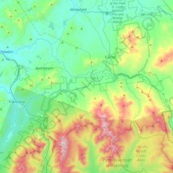
Name: Topografische Karte Bethlehem, Höhe, Relief.
Durchschnittliche Höhe: 528 m
Minimale Höhe: 183 m
Maximale Höhe: 1.572 m
According to the United States Census Bureau, the town has a total area of 91.0 square miles (235.7 km2), of which 90.6 square miles (234.7 km2) is land and 0.3 square miles (0.8 km2) is water, comprising 0.39% of the town. Bethlehem is drained by the Ammonoosuc, Gale, Zealand and Little rivers, together with Tuttle, Baker and Haystack brooks. Mount Cleveland, elevation 2,397 feet (731 m), and Mount Agassiz, 2,378 ft (725 m), rise to the south of the center of town. Town boundaries contain several of the famous 4,000-footers of New Hampshire: North Twin Mountain (the highest point in Bethlehem at 4,761 ft (1,451 m)), Mount Hale, Mount Tom, Mount Field and Mount Willey. Bethlehem lies almost fully within the Connecticut River watershed, though a tiny portion of the southeast corner of the town is in the Merrimack River watershed.