
Vielen Dank für die Unterstützung dieser Website ❤️
Spenden
Spenden
Rüste dich für dein nächstes Abenteuer:
Als Amazon-Partner verdient diese Website an qualifizierten Käufen, ohne zusätzliche Kosten für Sie.
Topografische Karte Santo Tomas
Klicken Sie auf die Karte, um die Höhe anzuzeigen.
Vielen Dank für die Unterstützung dieser Website ❤️
Spenden
Spenden
Rüste dich für dein nächstes Abenteuer:
Als Amazon-Partner verdient diese Website an qualifizierten Käufen, ohne zusätzliche Kosten für Sie.
Über diese Karte
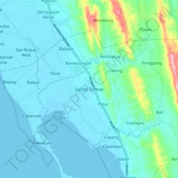
Name: Topografische Karte Santo Tomas, Höhe, Relief.
Ort: Santo Tomas, La Union, Ilocos Region, 2505, Philippines (16.24235 120.34672 16.32235 120.42672)
Durchschnittliche Höhe: 40 m
Minimale Höhe: -1 m
Maximale Höhe: 281 m
Vielen Dank für die Unterstützung dieser Website ❤️
Spenden
Spenden
Rüste dich für dein nächstes Abenteuer:
Als Amazon-Partner verdient diese Website an qualifizierten Käufen, ohne zusätzliche Kosten für Sie.