
Topografische Karte Wieliczka
Interaktive Karte
Klicken Sie auf die Karte, um die Höhe anzuzeigen.
Über diese Karte
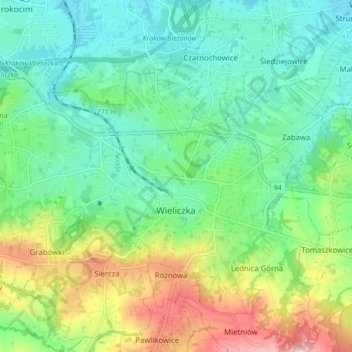
Name: Topografische Karte Wieliczka, Höhe, Relief.
Durchschnittliche Höhe: 270 m
Minimale Höhe: 203 m
Maximale Höhe: 421 m
The town lies in a valley between two ridges that stretch from west to east: south Wieliczka foothills, north Bogucice sands, including the Wieliczka-Gdów Upland. The south ridge is higher, while the northern ridge leads to national road 94. Near the town lies the A4 highway (E40 European route), which connects Kraków with Poland's south western and south eastern regions. Despite the small area, the city's relative altitude accounts for more than 137 –m–: the highest mountain reaches 361,8 metres above the sea, and the lowest point lies at an altitude of 224 metres above sea level.
Andere topografische Karten
Klicken Sie auf eine Karte, um ihre Topografie, ihre Höhe und ihr Relief anzuzeigen.
Grabówki
Poland > Lesser Poland Voivodeship > Wieliczka County
Grabówki, gmina Wieliczka, Wieliczka County, Lesser Poland Voivodeship, Poland
Durchschnittliche Höhe: 298 m
Niepołomice
Poland > Lesser Poland Voivodeship > Wieliczka County > Niepołomice
Niepołomice, gmina Niepołomice, Wieliczka County, Lesser Poland Voivodeship, 32-005, Poland
Durchschnittliche Höhe: 202 m