
Topografische Karte Mount Baldy
Interaktive Karte
Klicken Sie auf die Karte, um die Höhe anzuzeigen.
Über diese Karte
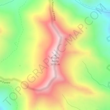
Name: Topografische Karte Mount Baldy, Höhe, Relief.
Ort: Mount Baldy, Gunnison County, Colorado, United States (38.99355 -107.04621 38.99365 -107.04611)
Durchschnittliche Höhe: 3.489 m
Minimale Höhe: 3.098 m
Maximale Höhe: 3.894 m
Andere topografische Karten
Klicken Sie auf eine Karte, um ihre Topografie, ihre Höhe und ihr Relief anzuzeigen.
Crested Butte
United States > Colorado > Gunnison County
Crested Butte, Gunnison County, Colorado, 81224, United States
Durchschnittliche Höhe: 2.798 m
Gothic
United States > Colorado > Gunnison County
Gothic, Gunnison County, Colorado, United States
Durchschnittliche Höhe: 3.140 m
Marble
United States > Colorado > Gunnison County
Marble, Gunnison County, Colorado, United States
Durchschnittliche Höhe: 2.611 m
Almont
United States > Colorado > Gunnison County
Almont, Gunnison County, Colorado, United States
Durchschnittliche Höhe: 2.578 m
Crested Butte South
United States > Colorado > Gunnison County
Crested Butte South, Gunnison County, Colorado, United States
Durchschnittliche Höhe: 2.742 m
Gunnison
United States > Colorado > Gunnison County
Gunnison, Gunnison County, Colorado, United States
Durchschnittliche Höhe: 2.369 m