
Spenden
Rüste dich für dein nächstes Abenteuer:
Als Amazon-Partner verdient diese Website an qualifizierten Käufen, ohne zusätzliche Kosten für Sie.
Topografische Karte Rye
Klicken Sie auf die Karte, um die Höhe anzuzeigen.
Spenden
Rüste dich für dein nächstes Abenteuer:
Als Amazon-Partner verdient diese Website an qualifizierten Käufen, ohne zusätzliche Kosten für Sie.
Rye
Rye has a subtropical highland climate (Köppen Cfb), a climate type usually associated with maritime regions, but is also found in high elevation areas in which summer temperatures are moderated by altitude. Precipitation exceeds that of semi-arid places, and average winter temperatures exceed freezing (O°C, 32 °F). This isolated pocket of climate exists due to the orographic enhancement of precipitation levels and summers moderated by altitude. Despite its climate Rye has much in common with other locations in its part of Colorado. Although conditions are not wet at any time of year, there is increased precipitation in March and April, as well as a snowfall maximum in March, with the snowiest periods being November and January through April. The North American Monsoon creates a second wet period in June and July. This climate features summers with warm daytime temperatures and mild to cool nights, along with chilly and snowy winters. Typical of its region, winters are quite variable, with December–February temperatures having ranged from as low as −36 °F (−38 °C) to as high as 76 °F (24.4 °C). The all-time record high is 101 °F (38.3 °C), set on June 21, 1981, and the all-time record low is −36 °F (−37.8 °C), set on January 12, 1963.
Spenden
Rüste dich für dein nächstes Abenteuer:
Als Amazon-Partner verdient diese Website an qualifizierten Käufen, ohne zusätzliche Kosten für Sie.
Über diese Karte
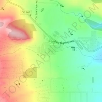
Name: Topografische Karte Rye, Höhe, Relief.
Ort: Rye, Pueblo County, Colorado, United States (37.91799 -104.93739 37.92419 -104.92841)
Durchschnittliche Höhe: 2.090 m
Minimale Höhe: 2.004 m
Maximale Höhe: 2.199 m
Spenden
Rüste dich für dein nächstes Abenteuer:
Als Amazon-Partner verdient diese Website an qualifizierten Käufen, ohne zusätzliche Kosten für Sie.
Andere topografische Karten
Klicken Sie auf eine Karte, um ihre Topografie, ihre Höhe und ihr Relief anzuzeigen.
Spenden
Rüste dich für dein nächstes Abenteuer:
Als Amazon-Partner verdient diese Website an qualifizierten Käufen, ohne zusätzliche Kosten für Sie.
North Avondale
United States > Colorado > Pueblo County > North Avondale
Durchschnittliche Höhe: 1.390 m