
Topografische Karte Dospat
Interaktive Karte
Klicken Sie auf die Karte, um die Höhe anzuzeigen.
Über diese Karte
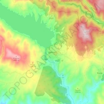
Name: Topografische Karte Dospat, Höhe, Relief.
Ort: Dospat, Smolyan, 4831, Bulgaria (41.60836 24.11933 41.68836 24.19933)
Durchschnittliche Höhe: 1.304 m
Minimale Höhe: 1.058 m
Maximale Höhe: 1.647 m
The town was probably founded by Despot Alexius Slav in the 12th or 13th century, from whose title (despot) its name is very likely derived. Dospat Dam is the highest dam in Bulgaria by altitude and, with its 22 km2 of water area, the second largest in capacity. It is fed by the River Dospat. At the bottom of the lake is a former German military airport from the Second World War.
Andere topografische Karten
Klicken Sie auf eine Karte, um ihre Topografie, ihre Höhe und ihr Relief anzuzeigen.