
Topografische Karte Mount Arvon
Interaktive Karte
Klicken Sie auf die Karte, um die Höhe anzuzeigen.
Über diese Karte
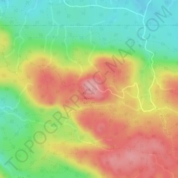
Name: Topografische Karte Mount Arvon, Höhe, Relief.
Durchschnittliche Höhe: 526 m
Minimale Höhe: 455 m
Maximale Höhe: 600 m
Mount Arvon, elevation 1,979 feet (603 m), is the highest natural point in the U.S. state of Michigan. Located in L'Anse Township, Baraga County, Mount Arvon is part of the Huron Mountains. It rises about eight miles (13 km) south of Lake Superior (elevation 591 feet [180 m]). On the list of highest natural points in each U.S. state, Mount Arvon ranks 38th. It is the highest natural point in the East North Central states.
Andere topografische Karten
Klicken Sie auf eine Karte, um ihre Topografie, ihre Höhe und ihr Relief anzuzeigen.
L'Anse Township
United States > Michigan > Baraga County
L'Anse Township, Baraga County, Michigan, 49946, United States
Durchschnittliche Höhe: 388 m
Aura
United States > Michigan > Baraga County > Aura
Aura, L'Anse Township, Baraga County, Michigan, United States
Durchschnittliche Höhe: 240 m
L'Anse
United States > Michigan > Baraga County > L'Anse
L'Anse, L'Anse Township, Baraga County, Michigan, 49946, United States
Durchschnittliche Höhe: 224 m
Ruth Lake
United States > Michigan > Baraga County > Three Lakes
Ruth Lake, Three Lakes, Spurr Township, Baraga County, Michigan, United States
Durchschnittliche Höhe: 507 m