
Spenden
Rüste dich für dein nächstes Abenteuer:
Als Amazon-Partner verdient diese Website an qualifizierten Käufen, ohne zusätzliche Kosten für Sie.
Topografische Karte Page
Klicken Sie auf die Karte, um die Höhe anzuzeigen.
Spenden
Rüste dich für dein nächstes Abenteuer:
Als Amazon-Partner verdient diese Website an qualifizierten Käufen, ohne zusätzliche Kosten für Sie.
Über diese Karte
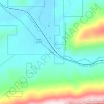
Name: Topografische Karte Page, Höhe, Relief.
Ort: Page, LeFlore County, Oklahoma, United States (34.69066 -94.56967 34.73066 -94.52967)
Durchschnittliche Höhe: 388 m
Minimale Höhe: 260 m
Maximale Höhe: 765 m
Spenden
Rüste dich für dein nächstes Abenteuer:
Als Amazon-Partner verdient diese Website an qualifizierten Käufen, ohne zusätzliche Kosten für Sie.
Andere topografische Karten
Klicken Sie auf eine Karte, um ihre Topografie, ihre Höhe und ihr Relief anzuzeigen.
Poteau
United States > Oklahoma > LeFlore County
The city is located in the valley below Cavanal Hill, dubbed the "World's Highest Hill" with a signed elevation of 1,999 feet (609 m). The location was a subject of extensive coal mining in the first half of the 20th Century, and a railway, eventually called the Poteau and Cavanal Mountain Railroad, served the…
Durchschnittliche Höhe: 189 m
Spenden
Rüste dich für dein nächstes Abenteuer:
Als Amazon-Partner verdient diese Website an qualifizierten Käufen, ohne zusätzliche Kosten für Sie.
Poteau
United States > Oklahoma > LeFlore County
The city is located in the valley below Cavanal Hill, dubbed the "World's Highest Hill" with a signed elevation of 1,999 feet (609 m). The location was a subject of extensive coal mining in the first half of the 20th Century, and a railway, eventually called the Poteau and Cavanal Mountain Railroad, served the…
Durchschnittliche Höhe: 189 m
Poteau
United States > Oklahoma > LeFlore County
The city is located in the valley below Cavanal Hill, dubbed the "World's Highest Hill" with a signed elevation of 1,999 feet (609 m). The location was a subject of extensive coal mining in the first half of the 20th century, and a railway, eventually called the Poteau and Cavanal Mountain Railroad, served the…
Durchschnittliche Höhe: 189 m
Spenden
Rüste dich für dein nächstes Abenteuer:
Als Amazon-Partner verdient diese Website an qualifizierten Käufen, ohne zusätzliche Kosten für Sie.