
Topografische Karte Silvia
Interaktive Karte
Klicken Sie auf die Karte, um die Höhe anzuzeigen.
Über diese Karte
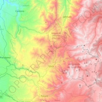
Name: Topografische Karte Silvia, Höhe, Relief.
Ort: Silvia, Cauca, Colombie (2.53479 -76.51627 2.78955 -76.17426)
Durchschnittliche Höhe: 2.688 m
Minimale Höhe: 1.379 m
Maximale Höhe: 3.834 m
Andere topografische Karten
Klicken Sie auf eine Karte, um ihre Topografie, ihre Höhe und ihr Relief anzuzeigen.
Comuna 9
Colombie > Cauca > Perímetro Urbano Popayán
Comuna 9, Perímetro Urbano Popayán, Popayán, Centro, Cauca, RAP Pacífico, 190004, Colombie
Durchschnittliche Höhe: 1.701 m
Comuna 1
Colombie > Cauca > Perímetro Urbano Popayán
Comuna 1, Perímetro Urbano Popayán, Popayán, Centro, Cauca, RAP Pacífico, Colombie
Durchschnittliche Höhe: 1.760 m
Perímetro Urbano Popayán
Perímetro Urbano Popayán, Popayán, Centro, Cauca, RAP Pacífico, Colombie
Durchschnittliche Höhe: 1.777 m