
Topografische Karte Village of Whitesboro
Interaktive Karte
Klicken Sie auf die Karte, um die Höhe anzuzeigen.
Über diese Karte
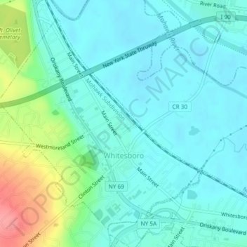
Name: Topografische Karte Village of Whitesboro, Höhe, Relief.
Durchschnittliche Höhe: 138 m
Minimale Höhe: 119 m
Maximale Höhe: 203 m
Andere topografische Karten
Klicken Sie auf eine Karte, um ihre Topografie, ihre Höhe und ihr Relief anzuzeigen.
Wright Settlement
United States > New York > Oneida County > City of Rome
Wright Settlement, City of Rome, Oneida County, New York, 13441, United States
Durchschnittliche Höhe: 174 m
Village of Oriskany
United States > New York > Oneida County
Village of Oriskany, Town of Whitestown, Oneida County, New York, United States
Durchschnittliche Höhe: 145 m
Town of Camden
United States > New York > Oneida County
Town of Camden, Oneida County, New York, 13316, United States
Durchschnittliche Höhe: 214 m
Village of Yorkville
United States > New York > Oneida County
Village of Yorkville, Town of Whitestown, Oneida County, New York, United States
Durchschnittliche Höhe: 138 m
Village of Oriskany Falls
United States > New York > Oneida County > Village of Oriskany Falls
Village of Oriskany Falls, Town of Augusta, Oneida County, New York, United States
Durchschnittliche Höhe: 332 m
Town of Forestport
United States > New York > Oneida County
Town of Forestport, Oneida County, New York, United States
Durchschnittliche Höhe: 366 m
Lee
United States > New York > Oneida County > Lee
Lee, Town of Lee, Oneida County, New York, United States
Durchschnittliche Höhe: 164 m
City of Utica
United States > New York > Oneida County
City of Utica, Oneida County, New York, United States
Durchschnittliche Höhe: 183 m