
Topografische Karte Kaziranga National Park and Tiger Reserve
Interaktive Karte
Klicken Sie auf die Karte, um die Höhe anzuzeigen.
Über diese Karte
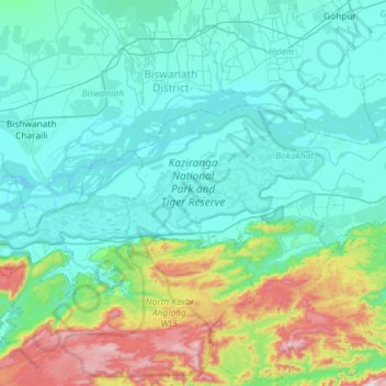
Name: Topografische Karte Kaziranga National Park and Tiger Reserve, Höhe, Relief.
Durchschnittliche Höhe: 202 m
Minimale Höhe: 58 m
Maximale Höhe: 915 m
The park is approximately 40 km (25 mi) in length from east to west, and 13 km (8 mi) in breadth from north to south. Kaziranga covers an area of 378 km2 (146 sq mi), with approximately 51.14 km2 (20 sq mi) lost to erosion in recent years. A total addition of 429 km2 (166 sq mi) along the present boundary of the park has been made and designated with separate national park status to provide extended habitat for increasing the population of wildlife or, as a corridor for safe movement of animals to Karbi Anglong Hills. Elevation ranges from 40 m (131 ft) to 80 m (262 ft). The park area is circumscribed by the Brahmaputra River, which forms the northern and eastern boundaries, and the Mora Diphlu, which forms the southern boundary. Other notable rivers within the park are the Diphlu and Mora Dhansiri.
Andere topografische Karten
Klicken Sie auf eine Karte, um ihre Topografie, ihre Höhe und ihr Relief anzuzeigen.
Numaligarh
India > Assam > Bokakhat > Numaligarh
Numaligarh, Bokakhat, Golaghat, Assam, 785615, India
Durchschnittliche Höhe: 87 m