
Topografische Karte Koło
Interaktive Karte
Klicken Sie auf die Karte, um die Höhe anzuzeigen.
Über diese Karte
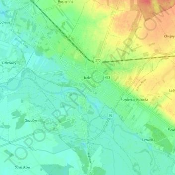
Name: Topografische Karte Koło, Höhe, Relief.
Ort: Koło, Koło County, Greater Poland Voivodeship, Poland (52.16735 18.59196 52.22942 18.67953)
Durchschnittliche Höhe: 100 m
Minimale Höhe: 84 m
Maximale Höhe: 133 m
Andere topografische Karten
Klicken Sie auf eine Karte, um ihre Topografie, ihre Höhe und ihr Relief anzuzeigen.
Dąbie
Poland > Greater Poland Voivodeship > Koło County > Dąbie > Dąbie
Dąbie, gmina Dąbie, Koło County, Greater Poland Voivodeship, 62-660, Poland
Durchschnittliche Höhe: 103 m
Karszew
Poland > Greater Poland Voivodeship > Koło County > Karszew
Karszew, gmina Dąbie, Koło County, Greater Poland Voivodeship, 62-660, Poland
Durchschnittliche Höhe: 106 m