
Spenden
Rüste dich für dein nächstes Abenteuer:
Als Amazon-Partner verdient diese Website an qualifizierten Käufen, ohne zusätzliche Kosten für Sie.
Topografische Karte Half Dome
Klicken Sie auf die Karte, um die Höhe anzuzeigen.
Spenden
Rüste dich für dein nächstes Abenteuer:
Als Amazon-Partner verdient diese Website an qualifizierten Käufen, ohne zusätzliche Kosten für Sie.
Half Dome
The Half Dome Cable Route hike runs from the valley floor to the top of the dome in 8.2 mi (13 km) (via the Mist Trail), with 4,800 ft (1,460 m) of elevation gain. The length and difficulty of the trail used to keep it less crowded than other park trails, but in recent years the trail traffic has grown to as many as 800 people a day. The hike can be done from the valley floor in a single long day, but many people break it up by camping overnight in Little Yosemite Valley. The trail climbs past Vernal Fall and Nevada Fall, then continues into Little Yosemite Valley, then north to the base of the northeast ridge of Half Dome itself.
Spenden
Rüste dich für dein nächstes Abenteuer:
Als Amazon-Partner verdient diese Website an qualifizierten Käufen, ohne zusätzliche Kosten für Sie.
Über diese Karte
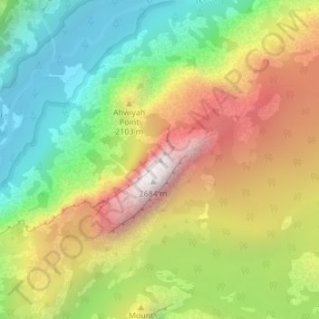
Name: Topografische Karte Half Dome, Höhe, Relief.
Ort: Half Dome, Mariposa County, California, United States (37.74595 -119.53330 37.74605 -119.53320)
Durchschnittliche Höhe: 1.887 m
Minimale Höhe: 1.241 m
Maximale Höhe: 2.693 m
Spenden
Rüste dich für dein nächstes Abenteuer:
Als Amazon-Partner verdient diese Website an qualifizierten Käufen, ohne zusätzliche Kosten für Sie.
Andere topografische Karten
Klicken Sie auf eine Karte, um ihre Topografie, ihre Höhe und ihr Relief anzuzeigen.
Yosemite Valley
United States > California > Mariposa County > Yosemite Village
Durchschnittliche Höhe: 2.016 m
Echo Valley
United States > California > Mariposa County
Echo Valley is a valley in Yosemite National Park, at an elevation of 7,021 feet (2,140 m). It is located along Echo Creek, about 3 miles (5 km) west of Merced Lake, at 37°44′38″N 119°26′03″W / 37.7438°N 119.4343°W / 37.7438; -119.4343. It is bounded on the south by the Merced River.
Durchschnittliche Höhe: 2.333 m
Spenden
Rüste dich für dein nächstes Abenteuer:
Als Amazon-Partner verdient diese Website an qualifizierten Käufen, ohne zusätzliche Kosten für Sie.
Yosemite Valley
United States > California > Mariposa County > Yosemite Village
Durchschnittliche Höhe: 2.012 m
Yosemite Valley
United States > California > Mariposa County > Yosemite Village
Durchschnittliche Höhe: 2.016 m