Topografische Karte Shallmar
Interaktive Karte
Klicken Sie auf die Karte, um die Höhe anzuzeigen.
Über diese Karte
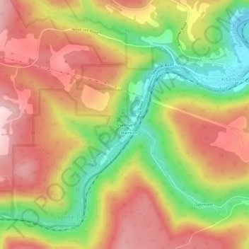
Name: Topografische Karte Shallmar, Höhe, Relief.
Ort: Shallmar, Garrett County, Maryland, 21538, United States (39.35954 -79.22476 39.39954 -79.18476)
Durchschnittliche Höhe: 653 m
Minimale Höhe: 477 m
Maximale Höhe: 801 m
Andere topografische Karten
Klicken Sie auf eine Karte, um ihre Topografie, ihre Höhe und ihr Relief anzuzeigen.
Swanton
United States > Maryland > Garrett County
Swanton, Garrett County, Maryland, 21561, United States
Durchschnittliche Höhe: 789 m
Deer Park
United States > Maryland > Garrett County
Deer Park, Garrett County, Maryland, United States
Durchschnittliche Höhe: 774 m
Loch Lynn Heights
United States > Maryland > Garrett County
Loch Lynn Heights, Garrett County, Maryland, United States
Durchschnittliche Höhe: 747 m
Redhouse
United States > Maryland > Garrett County
Redhouse, Garrett County, Maryland, United States
Durchschnittliche Höhe: 777 m
Deep Creek Lake
United States > Maryland > Garrett County > McHenry
Deep Creek Lake, McHenry, Garrett County, Maryland, 21541, United States
Durchschnittliche Höhe: 793 m
Mountain Lake Park
United States > Maryland > Garrett County
Mountain Lake Park, Garrett County, Maryland, United States
Durchschnittliche Höhe: 749 m
Finzel
United States > Maryland > Garrett County > Finzel
Finzel, Garrett County, Maryland, United States
Durchschnittliche Höhe: 778 m
McHenry
United States > Maryland > Garrett County
McHenry, Garrett County, Maryland, 21541, United States
Durchschnittliche Höhe: 817 m
Selbysport
United States > Maryland > Garrett County
Selbysport, Garrett County, Maryland, 21531, United States
Durchschnittliche Höhe: 553 m
Accident
United States > Maryland > Garrett County
Accident, Garrett County, Maryland, United States
Durchschnittliche Höhe: 751 m
Friendsville
United States > Maryland > Garrett County
Friendsville, Garrett County, Maryland, United States
Durchschnittliche Höhe: 528 m
Oakland
United States > Maryland > Garrett County
Oakland, Garrett County, Maryland, United States
Durchschnittliche Höhe: 763 m
Meadow Mountain
United States > Maryland > Garrett County
Meadow Mountain, Garrett County, Maryland, 21522, United States
Durchschnittliche Höhe: 798 m
Bloomington
United States > Maryland > Garrett County > Bloomington
Bloomington, Garrett County, Maryland, 21523, United States
Durchschnittliche Höhe: 405 m
Kitzmiller
United States > Maryland > Garrett County
Kitzmiller, Garrett County, Maryland, United States
Durchschnittliche Höhe: 604 m
Swanton
United States > Maryland > Garrett County > Swanton
Swanton, Garrett County, Maryland, United States
Durchschnittliche Höhe: 773 m
Hoyes Run
United States > Maryland > Garrett County > Hoyes Run
Hoyes Run, Garrett County, Maryland, United States
Durchschnittliche Höhe: 756 m
Bloomington
United States > Maryland > Garrett County
Bloomington, Garrett County, Maryland, 21523, United States
Durchschnittliche Höhe: 436 m
Grantsville
United States > Maryland > Garrett County
Grantsville, Garrett County, Maryland, United States
Durchschnittliche Höhe: 706 m
Savage River
United States > Maryland > Garrett County > Bloomington
Savage River, Bloomington, Garrett County, Maryland, 21523, United States
Durchschnittliche Höhe: 687 m