
Topografische Karte Athlone
Interaktive Karte
Klicken Sie auf die Karte, um die Höhe anzuzeigen.
Über diese Karte
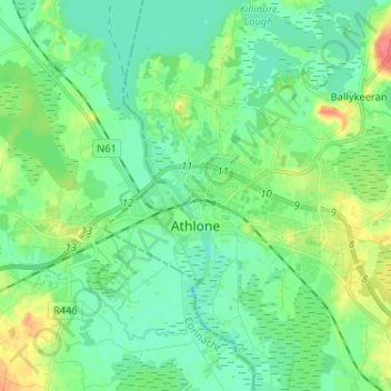
Name: Topografische Karte Athlone, Höhe, Relief.
Ort: Athlone, County Westmeath, Leinster, Ireland (53.40664 -8.01690 53.45088 -7.88754)
Durchschnittliche Höhe: 43 m
Minimale Höhe: 28 m
Maximale Höhe: 81 m
Andere topografische Karten
Klicken Sie auf eine Karte, um ihre Topografie, ihre Höhe und ihr Relief anzuzeigen.
Torque
Torque, Newtown ED, The Municipal District of Athlone — Moate, County Westmeath, Leinster, Ireland
Durchschnittliche Höhe: 92 m
Abbeyland and Charlestown or Ballynamonaster
Abbeyland and Charlestown or Ballynamonaster, Kilbixy ED, The Municipal District of Athlone — Moate, County Westmeath, Leinster, Ireland
Durchschnittliche Höhe: 65 m
Meehan
Meehan, Moydrum ED, The Municipal District of Athlone — Moate, County Westmeath, Leinster, Ireland
Durchschnittliche Höhe: 40 m
Ballymore
Ireland > County Westmeath > Ballymore
Ballymore, The Municipal District of Athlone — Moate, County Westmeath, Leinster, Ireland
Durchschnittliche Höhe: 83 m