
Topografische Karte San Jose
Interaktive Karte
Klicken Sie auf die Karte, um die Höhe anzuzeigen.
Über diese Karte
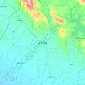
Name: Topografische Karte San Jose, Höhe, Relief.
Ort: San Jose, Nueva Ecija, Central Luzon, 3121, Philippines (15.63174 120.82915 15.95174 121.14915)
Durchschnittliche Höhe: 175 m
Minimale Höhe: 38 m
Maximale Höhe: 1.250 m
The city of San Jose lies at 15° 47' North, 120° 59' East in Central Luzon. The estimated elevation at these coordinates is approximately 109.9 meters or 360.4 feet above mean sea level.