
Topografische Karte Oroville Dam
Interaktive Karte
Klicken Sie auf die Karte, um die Höhe anzuzeigen.
Über diese Karte
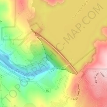
Name: Topografische Karte Oroville Dam, Höhe, Relief.
Ort: Oroville Dam, Butte County, California, United States (39.53209 -121.49169 39.54261 -121.47773)
Durchschnittliche Höhe: 226 m
Minimale Höhe: 65 m
Maximale Höhe: 370 m
Andere topografische Karten
Klicken Sie auf eine Karte, um ihre Topografie, ihre Höhe und ihr Relief anzuzeigen.
Lake Oroville
United States > California > Butte County
Lake Oroville, Butte County, California, United States
Durchschnittliche Höhe: 392 m
Paradise Dam
United States > California > Butte County
Paradise Dam, Butte County, California, United States
Durchschnittliche Höhe: 789 m
North Fork Feather River
United States > California > Butte County
North Fork Feather River, Butte County, CAL Fire Northern Region, California, United States
Durchschnittliche Höhe: 714 m
Merrimac
United States > California > Butte County
Merrimac, Butte County, CAL Fire Northern Region, California, United States
Durchschnittliche Höhe: 1.191 m
Paradise Pines
United States > California > Butte County
Paradise Pines, Butte County, CAL Fire Northern Region, California, United States
Durchschnittliche Höhe: 724 m
Peachton
United States > California > Butte County
Peachton, Butte County, CAL Fire Northern Region, California, 95948, United States
Durchschnittliche Höhe: 30 m
Pulga
United States > California > Butte County > Pulga
Pulga, Butte County, California, 95980, United States
Durchschnittliche Höhe: 750 m
Paradise
United States > California > Butte County
Paradise, Butte County, California, 95969, United States
Durchschnittliche Höhe: 464 m
Chico
United States > California > Butte County
Chico, Butte County, California, United States
Durchschnittliche Höhe: 94 m
Big Bend
United States > California > Butte County
Big Bend, Butte County, CAL Fire Northern Region, California, United States
Durchschnittliche Höhe: 574 m