
Topografische Karte Aroostook County
Interaktive Karte
Klicken Sie auf die Karte, um die Höhe anzuzeigen.
Über diese Karte
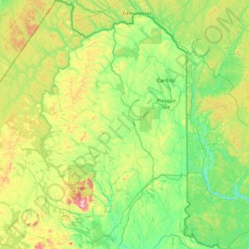
Name: Topografische Karte Aroostook County, Höhe, Relief.
Ort: Aroostook County, Maine, United States (45.57286 -70.02320 47.45984 -67.75063)
Durchschnittliche Höhe: 274 m
Minimale Höhe: 38 m
Maximale Höhe: 1.497 m
According to the U.S. Census Bureau, the county has a total area of 6,828 square miles (17,680 km2), of which 6,671 square miles (17,280 km2) is land and 156 square miles (400 km2) (2.3%) is water. Aroostook County is Maine's largest county by area, about the size of Connecticut and Rhode Island combined. The county high point is Peaked Mountain, elevation 2,230 feet (680 m), whose western slopes are in the north east corner of Piscataquis County.
Andere topografische Karten
Klicken Sie auf eine Karte, um ihre Topografie, ihre Höhe und ihr Relief anzuzeigen.
Westport Island
United States > Maine > Lincoln County > Westport Island
Westport Island, Lincoln County, Maine, United States
Durchschnittliche Höhe: 21 m
Sugarloaf
United States > Maine > Oxford County > Dixfield
Sugarloaf, Dixfield, Oxford County, Maine, 04224, United States
Durchschnittliche Höhe: 237 m
Clark Mountain
United States > Maine > Androscoggin County > Greene
Clark Mountain, Greene, Androscoggin County, Maine, 04236, United States
Durchschnittliche Höhe: 134 m
Monson
United States > Maine > Piscataquis County
Monson, Piscataquis County, Maine, 04464, United States
Durchschnittliche Höhe: 250 m
Parlin Pond
United States > Maine > Somerset County > Parlin Pond Township
Parlin Pond, Parlin Pond Township, Somerset County, Maine, United States
Durchschnittliche Höhe: 529 m
Belgrade
United States > Maine > Kennebec County
Belgrade, Kennebec County, Maine, United States
Durchschnittliche Höhe: 104 m
Cushing
United States > Maine > Knox County
Cushing, Knox County, Maine, 04563, United States
Durchschnittliche Höhe: 13 m
Dyer Harbor
United States > Maine > Washington County > Steuben
Dyer Harbor, Steuben, Washington County, Maine, 04680, United States
Durchschnittliche Höhe: 14 m
York
United States > Maine > York County
York, York County, Maine, United States
Durchschnittliche Höhe: 18 m
Madrid Township
United States > Maine > Franklin County
Madrid Township, Franklin County, Maine, United States
Durchschnittliche Höhe: 522 m
Brownville
United States > Maine > Piscataquis County
Brownville, Piscataquis County, Maine, 04414, United States
Durchschnittliche Höhe: 160 m
Sand Pond
United States > Maine > Kennebec County > Monmouth
Sand Pond, Monmouth, Kennebec County, Maine, 04259, United States
Durchschnittliche Höhe: 82 m
Folly Pond
United States > Maine > Knox County > Vinalhaven
Folly Pond, Vinalhaven, Knox County, Maine, United States
Durchschnittliche Höhe: 16 m
Trevett
United States > Maine > Lincoln County > Boothbay
Trevett, Boothbay, Lincoln County, Maine, 04571, United States
Durchschnittliche Höhe: 13 m
Casco
United States > Maine > Cumberland County
Casco, Cumberland County, Maine, 04015, United States
Durchschnittliche Höhe: 122 m
Holdsworth Park
United States > Maine > York County > Sanford
Holdsworth Park, 04083, Sanford, York County, Maine, United States
Durchschnittliche Höhe: 130 m
Gouldsboro
United States > Maine > Hancock County
Gouldsboro, Hancock County, Maine, United States
Durchschnittliche Höhe: 16 m
Steuben
United States > Maine > Washington County
Steuben, Washington County, Maine, 04680, United States
Durchschnittliche Höhe: 23 m
Buxton
United States > Maine > York County
Buxton, York County, Maine, 04093, United States
Durchschnittliche Höhe: 61 m
Greenwood
United States > Maine > Oxford County
Greenwood, Oxford County, Maine, 04255, United States
Durchschnittliche Höhe: 295 m
Milton Township
United States > Maine > Oxford County
Milton Township, Oxford County, Maine, 04219, United States
Durchschnittliche Höhe: 309 m
Sebago
United States > Maine > Cumberland County
Sebago, Cumberland County, Maine, 04029, United States
Durchschnittliche Höhe: 160 m
Sugar Island
United States > Maine > Penobscot County > Greenbush
Sugar Island, Greenbush, Penobscot County, Maine, 04418, United States
Durchschnittliche Höhe: 41 m
Bradbury Mountain
United States > Maine > Cumberland County > Pownal
Bradbury Mountain, Pownal, Cumberland County, Maine, 04069, United States
Durchschnittliche Höhe: 71 m
Pleasant Lake
United States > Maine > Oxford County > Otisfield
Pleasant Lake, Otisfield, Oxford County, Maine, 04270, United States
Durchschnittliche Höhe: 140 m
Winthrop
United States > Maine > Kennebec County
Winthrop, Kennebec County, Maine, 04364, United States
Durchschnittliche Höhe: 92 m
Gray Island
United States > Maine > Somerset County > Solon
Gray Island, Solon, Somerset County, Maine, United States
Durchschnittliche Höhe: 105 m
Lakeville
United States > Maine > Penobscot County
Lakeville, Penobscot County, Maine, United States
Durchschnittliche Höhe: 138 m
Plymouth
United States > Maine > Penobscot County
Plymouth, Penobscot County, Maine, 04969, United States
Durchschnittliche Höhe: 92 m
Wellington
United States > Maine > Piscataquis County
Wellington, Piscataquis County, Maine, United States
Durchschnittliche Höhe: 257 m
Mackamp
United States > Maine > Somerset County
Mackamp, Long Pond Township, Somerset County, Maine, United States
Durchschnittliche Höhe: 395 m
Sebec
United States > Maine > Piscataquis County
Sebec, Piscataquis County, Maine, 04481, United States
Durchschnittliche Höhe: 139 m
West Forks Plantation
United States > Maine > Somerset County
West Forks Plantation, Somerset County, Maine, 04985, United States
Durchschnittliche Höhe: 387 m
Tiger Rips
United States > Maine > Penobscot County
Tiger Rips, T6 R7 WELS, Penobscot County, Maine, United States
Durchschnittliche Höhe: 226 m
Johns Island
United States > Maine > Hancock County > Swan's Island
Johns Island, Swan's Island, Hancock County, Maine, United States
Durchschnittliche Höhe: 0 m
Sister Islands
United States > Maine > Hancock County > Swan's Island
Sister Islands, Swan's Island, Hancock County, Maine, 04635, United States
Durchschnittliche Höhe: 9 m
Rainbow Mountain
United States > Maine > Piscataquis County
Rainbow Mountain, Piscataquis County, Maine, United States
Durchschnittliche Höhe: 394 m
Paris
United States > Maine > Oxford County
Paris, Oxford County, Maine, 04281, United States
Durchschnittliche Höhe: 207 m
Sanford
United States > Maine > York County
Sanford, York County, Maine, United States
Durchschnittliche Höhe: 103 m
Trenton
United States > Maine > Hancock County
Trenton, Hancock County, Maine, 04705, United States
Durchschnittliche Höhe: 19 m
Washington
United States > Maine > Knox County
Washington, Knox County, Maine, 04574, United States
Durchschnittliche Höhe: 94 m
Kennebunkport
United States > Maine > York County
Kennebunkport, York County, Maine, 04046, United States
Durchschnittliche Höhe: 12 m
Hallowell
United States > Maine > Kennebec County
Hallowell, Kennebec County, Maine, 04347, United States
Durchschnittliche Höhe: 63 m
Monhegan Island Plantation
United States > Maine > Lincoln County
Monhegan Island Plantation, Lincoln County, Maine, 04852, United States
Durchschnittliche Höhe: 0 m
Fairfield
United States > Maine > Somerset County
Fairfield, Somerset County, Maine, United States
Durchschnittliche Höhe: 64 m
Edmunds Township
United States > Maine > Washington County
Edmunds Township, Washington County, Maine, United States
Durchschnittliche Höhe: 20 m
The Sands
United States > Maine > Washington County > Addison
The Sands, Addison, Washington County, Maine, United States
Durchschnittliche Höhe: 0 m
Oxford County
Oxford County, Maine, United States, Bacon Hill
Durchschnittliche Höhe: 268 m
Montville
United States > Maine > Waldo County
Montville, Waldo County, Maine, United States
Durchschnittliche Höhe: 152 m