
Topografische Karte Mincio
Interaktive Karte
Klicken Sie auf die Karte, um die Höhe anzuzeigen.
Über diese Karte
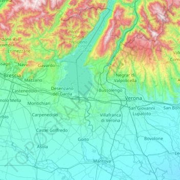
Name: Topografische Karte Mincio, Höhe, Relief.
Ort: Mincio, Lombardy, Italy (45.07000 10.62649 45.87305 10.98604)
Durchschnittliche Höhe: 368 m
Minimale Höhe: 7 m
Maximale Höhe: 2.207 m
Andere topografische Karten
Klicken Sie auf eine Karte, um ihre Topografie, ihre Höhe und ihr Relief anzuzeigen.
Lake Garda
Lake Garda, Brescia, Lombardy, Italy
Durchschnittliche Höhe: 571 m
Cascina Mentirate
Italy > Lombardy > Milan > Lacchiarella
Cascina Mentirate, Lacchiarella, Milan, Lombardy, 20084, Italy
Durchschnittliche Höhe: 98 m
Municipio 8 di Milano
Italy > Lombardy > Milan > Milan
Municipio 8 di Milano, Milan, Lombardy, Italy
Durchschnittliche Höhe: 138 m
Lago di Lei
Lago di Lei, Mottalla - Passo dell'Angeloga, Alpe Mottala, Piuro, Comunità Montana della Valchiavenna, SO, Lombardy, Italy
Durchschnittliche Höhe: 2.318 m
Bergamasque Alps and Prealps
Italy > Lombardy > Oltre il Colle
Bergamasque Alps and Prealps, Oltre il Colle, Comunità Montana della Valle Brembana, BG, Lombardy, Italy
Durchschnittliche Höhe: 977 m
Bernina Range
Bernina Range, Lanzada, Comunità Montana della Valtellina di Sondrio, SO, Lombardy, Italy
Durchschnittliche Höhe: 2.084 m