
Topografische Karte No Name Peak
Interaktive Karte
Klicken Sie auf die Karte, um die Höhe anzuzeigen.
Über diese Karte
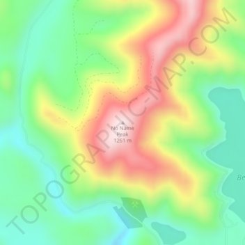
Name: Topografische Karte No Name Peak, Höhe, Relief.
Durchschnittliche Höhe: 981 m
Minimale Höhe: 800 m
Maximale Höhe: 1.247 m
Andere topografische Karten
Klicken Sie auf eine Karte, um ihre Topografie, ihre Höhe und ihr Relief anzuzeigen.
Lewis County
États-Unis d'Amérique > Washington
Lewis County, Washington, États-Unis d'Amérique
Durchschnittliche Höhe: 580 m
Audrey
États-Unis d'Amérique > Washington > Benton County
Audrey, Benton County, Washington, États-Unis d'Amérique
Durchschnittliche Höhe: 156 m
Kent
États-Unis d'Amérique > Washington > King County
Kent, King County, Washington, États-Unis d'Amérique
Durchschnittliche Höhe: 87 m
Anacortes
États-Unis d'Amérique > Washington > Skagit County
Anacortes, Skagit County, Washington, 98221, États-Unis d'Amérique
Durchschnittliche Höhe: 36 m
Grant County
États-Unis d'Amérique > Washington > Grant County
Grant County, Washington, États-Unis d'Amérique
Durchschnittliche Höhe: 563 m
Bellingham
États-Unis d'Amérique > Washington > Whatcom County > Bellingham
Bellingham, Whatcom County, Washington, 98225-3243, États-Unis d'Amérique
Durchschnittliche Höhe: 129 m
Lake Louis
États-Unis d'Amérique > Washington > Chelan County
Lake Louis, Chelan County, Washington, États-Unis d'Amérique
Durchschnittliche Höhe: 1.325 m
Sumas
États-Unis d'Amérique > Washington > Sumas
Sumas, Whatcom County, Washington, 98295, États-Unis d'Amérique
Durchschnittliche Höhe: 16 m
Wilderness
États-Unis d'Amérique > Washington > Wilderness
Wilderness, King County, Washington, 98038, États-Unis d'Amérique
Durchschnittliche Höhe: 154 m
Prevost
États-Unis d'Amérique > Washington > Prevost
Prevost, San Juan County, Washington, États-Unis d'Amérique
Durchschnittliche Höhe: 19 m
Longview
États-Unis d'Amérique > Washington > Longview
Longview, Cowlitz County, Washington, États-Unis d'Amérique
Durchschnittliche Höhe: 50 m
Maple Valley
États-Unis d'Amérique > Washington > King County
Maple Valley, King County, Washington, 98038, États-Unis d'Amérique
Durchschnittliche Höhe: 160 m
Bellevue
États-Unis d'Amérique > Washington > King County
Bellevue, King County, Washington, États-Unis d'Amérique
Durchschnittliche Höhe: 66 m
Mount Ross
États-Unis d'Amérique > Washington
Mount Ross, Whatcom County, Washington, États-Unis d'Amérique
Durchschnittliche Höhe: 1.337 m
Lacamas Lake
États-Unis d'Amérique > Washington > Camas
Lacamas Lake, Heritage Trail, Oak Park, Camas, Clark County, Washington, 98607, États-Unis d'Amérique
Durchschnittliche Höhe: 95 m
Mont Rainier
États-Unis d'Amérique > Washington
Mont Rainier, Pierce County, Washington, États-Unis d'Amérique
Durchschnittliche Höhe: 3.938 m
Sammamish
États-Unis d'Amérique > Washington > Sammamish
Sammamish, King County, Washington, États-Unis d'Amérique
Durchschnittliche Höhe: 97 m
Whatcom County
États-Unis d'Amérique > Washington
Whatcom County, Washington, États-Unis d'Amérique
Durchschnittliche Höhe: 753 m
Mount Terror
États-Unis d'Amérique > Washington
Mount Terror, Whatcom County, Washington, États-Unis d'Amérique
Durchschnittliche Höhe: 1.808 m
Redmond
États-Unis d'Amérique > Washington > Redmond
Redmond, King County, Washington, États-Unis d'Amérique
Durchschnittliche Höhe: 72 m
Tumtum
États-Unis d'Amérique > Washington > Tumtum
Tumtum, Stevens County, Washington, États-Unis d'Amérique
Durchschnittliche Höhe: 555 m
Spirit
États-Unis d'Amérique > Washington > Spirit
Spirit, Stevens County, Washington, États-Unis d'Amérique
Durchschnittliche Höhe: 731 m
Mount Price
États-Unis d'Amérique > Washington
Mount Price, King County, Washington, États-Unis d'Amérique
Durchschnittliche Höhe: 1.194 m
Langley
États-Unis d'Amérique > Washington > Langley
Langley, Island County, Washington, États-Unis d'Amérique
Durchschnittliche Höhe: 48 m