
Topografische Karte Bigrigg
Interaktive Karte
Klicken Sie auf die Karte, um die Höhe anzuzeigen.
Über diese Karte
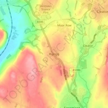
Name: Topografische Karte Bigrigg, Höhe, Relief.
Durchschnittliche Höhe: 75 m
Minimale Höhe: 8 m
Maximale Höhe: 132 m
Andere topografische Karten
Klicken Sie auf eine Karte, um ihre Topografie, ihre Höhe und ihr Relief anzuzeigen.
Redhills Quarry (disused, flooded)
United Kingdom > England > Cumbria > Borough of Copeland > Millom > Rottington
Redhills Quarry (disused, flooded), Rottington, Millom, Borough of Copeland, Cumbria, England, United Kingdom
Durchschnittliche Höhe: 6 m
Sca Fell
United Kingdom > England > Cumbria > Borough of Copeland
Sca Fell, Borough of Copeland, Cumbria, England, CA20 1EX, United Kingdom
Durchschnittliche Höhe: 619 m
Mosedale
United Kingdom > England > Cumbria > Borough of Copeland
Mosedale, Wasdale, Borough of Copeland, Cumbria, England, CA20 1EX, United Kingdom
Durchschnittliche Höhe: 405 m
Distington
United Kingdom > England > Cumbria > Borough of Copeland
Distington, Borough of Copeland, Cumbria, England, United Kingdom
Durchschnittliche Höhe: 130 m
Ravenglass
United Kingdom > England > Cumbria > Borough of Copeland
Ravenglass, Borough of Copeland, Cumbria, England, CA18 1SE, United Kingdom
Durchschnittliche Höhe: 21 m
Blea Tarn
United Kingdom > England > Cumbria > Borough of Copeland > Boot > Beckfoot
Blea Tarn, Beckfoot, Eskdale, Boot, Borough of Copeland, Cumbria, England, United Kingdom
Durchschnittliche Höhe: 144 m