
Topografische Karte Las Majadillas
Interaktive Karte
Klicken Sie auf die Karte, um die Höhe anzuzeigen.
Über diese Karte
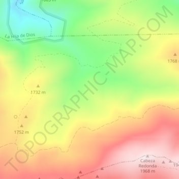
Name: Topografische Karte Las Majadillas, Höhe, Relief.
Ort: Las Majadillas, Sotalbo, Ávila, Castilla y León, España (40.48035 -4.94786 40.50035 -4.92786)
Durchschnittliche Höhe: 1.695 m
Minimale Höhe: 1.409 m
Maximale Höhe: 1.960 m
Andere topografische Karten
Klicken Sie auf eine Karte, um ihre Topografie, ihre Höhe und ihr Relief anzuzeigen.
El Zujar
España > Castilla y León > Sotalbo
El Zujar, Sotalbo, Ávila, Castilla y León, España
Durchschnittliche Höhe: 1.108 m
Pico Zapatero
España > Castilla y León > Sotalbo
Pico Zapatero, Sotalbo, Ávila, Castilla y León, España
Durchschnittliche Höhe: 1.782 m