
Topografische Karte Ropczyce
Interaktive Karte
Klicken Sie auf die Karte, um die Höhe anzuzeigen.
Über diese Karte
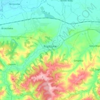
Name: Topografische Karte Ropczyce, Höhe, Relief.
Durchschnittliche Höhe: 250 m
Minimale Höhe: 190 m
Maximale Höhe: 382 m
Ropczyce is located east of Kraków and west of Rzeszów. The coordinates for Ropczyce: Latitude 50°0500' and Longitude 21°6167. In DMS or Degree, Minutes, & Seconds; Latitude 50°2'60N and Longitude is 21°37'0E. Its elevation is 240 metres (787 feet) above sea level. The time zone for Poland is UTC+1.