
Topografische Karte Kalamaki
Interaktive Karte
Klicken Sie auf die Karte, um die Höhe anzuzeigen.
Über diese Karte
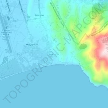
Name: Topografische Karte Kalamaki, Höhe, Relief.
Durchschnittliche Höhe: 58 m
Minimale Höhe: -4 m
Maximale Höhe: 461 m
Andere topografische Karten
Klicken Sie auf eine Karte, um ihre Topografie, ihre Höhe und ihr Relief anzuzeigen.
Lithakia
Greece > Peloponnese, Western Greece and the Ionian > Zakynthos Regional Unit
Lithakia, Zakynthos Municipality, Zakynthos Regional Unit, Ioanian Islands, Peloponnese, Western Greece and the Ionian, 290 92, Greece
Durchschnittliche Höhe: 153 m
Ναυάγιο
Greece > Peloponnese, Western Greece and the Ionian > Zakynthos Regional Unit
Ναυάγιο, κ. Βολίμων, Zakynthos Municipality, Zakynthos Regional Unit, Ioanian Islands, Peloponnese, Western Greece and the Ionian, Greece
Durchschnittliche Höhe: 125 m
Zakynthos
Greece > Peloponnese, Western Greece and the Ionian > Zakynthos Regional Unit
Zakynthos, Zakynthos Regional Unit, Ioanian Islands, Peloponnese, Western Greece and the Ionian, Greece
Durchschnittliche Höhe: 82 m
Vardiola in Tsilivi
Greece > Peloponnese, Western Greece and the Ionian > Zakynthos Regional Unit > Planos
Vardiola in Tsilivi, Τσιβιλή - Κάτω Γερακάρι, κ. Τραγακίου, Planos, Zakynthos Municipality, Zakynthos Regional Unit, Ioanian Islands, Peloponnese, Western Greece and the Ionian, 291 00, Greece
Durchschnittliche Höhe: 12 m
Alykanas
Greece > Peloponnese, Western Greece and the Ionian > Zakynthos Regional Unit
Alykanas, Zakynthos Municipality, Zakynthos Regional Unit, Ioanian Islands, Peloponnese, Western Greece and the Ionian, 290 90, Greece
Durchschnittliche Höhe: 16 m
Laganas
Greece > Peloponnese, Western Greece and the Ionian > Zakynthos Regional Unit > Laganas
Laganas, Zakynthos Municipality, Zakynthos Regional Unit, Ioanian Islands, Peloponnese, Western Greece and the Ionian, 29092, Greece
Durchschnittliche Höhe: 8 m