
Topografische Karte Gonzaga
Interaktive Karte
Klicken Sie auf die Karte, um die Höhe anzuzeigen.
Über diese Karte
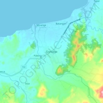
Name: Topografische Karte Gonzaga, Höhe, Relief.
Ort: Gonzaga, Cagayan, Cagayan Valley, 3513, Philippines (18.22120 121.95665 18.30120 122.03665)
Durchschnittliche Höhe: 38 m
Minimale Höhe: -1 m
Maximale Höhe: 237 m
It has a total land area of 56,743 hectares (140,220 acres), the majority of which remains undeveloped. It has large stretches of virgin forests, especially throughout the mountainous areas of the Sierra Madre mountain range. The highest elevation in the municipality is 1,130 metres (3,710 ft) above sea level, located at Mount Cagua in Barangay Magrafil.
Andere topografische Karten
Klicken Sie auf eine Karte, um ihre Topografie, ihre Höhe und ihr Relief anzuzeigen.
Caritan Norte
Philippines > Cagayan > Tuguegarao
Caritan Norte, Tuguegarao, Cagayan, Cagayan Valley, 3500, Philippines
Durchschnittliche Höhe: 24 m
Ballesteros
Ballesteros, Cagayan, Cagayan Valley, 3516, Philippines
Durchschnittliche Höhe: 3 m
Lablabig
Lablabig, Cagayan, Cagayan Valley, Philippines
Durchschnittliche Höhe: 85 m
Solana
Solana, Cagayan, Cagayan Valley, 3503, Philippines
Durchschnittliche Höhe: 33 m
Santa Praxedes
Santa Praxedes, Cagayan, Cagayan Valley, 3521, Philippines
Durchschnittliche Höhe: 157 m
Santa Maria
Santa Maria, Cagayan, Cagayan Valley, 3519, Philippines
Durchschnittliche Höhe: 28 m
Luzon
Philippines > Cagayan > Luzon
Luzon, Cagayan, Cagayan Valley, Philippines
Durchschnittliche Höhe: 70 m
Claveria
Philippines > Cagayan > Claveria
Claveria, Cagayan, Cagayan Valley, 3519, Philippines
Durchschnittliche Höhe: 31 m
Abulug
Philippines > Cagayan > Abulug
Abulug, Cagayan, Cagayan Valley, Philippines
Durchschnittliche Höhe: 2 m
Calog Sur
Philippines > Cagayan > Calog Sur
Calog Sur, Cagayan, Cagayan Valley, 3813, Philippines
Durchschnittliche Höhe: 8 m
Allacapan
Philippines > Cagayan > Allacapan
Allacapan, Cagayan, Cagayan Valley, Philippines
Durchschnittliche Höhe: 25 m
Tuguegarao
Tuguegarao, Cagayan, Cagayan Valley, 3500, Philippines
Durchschnittliche Höhe: 49 m
Alcala
Alcala, Cagayan, Cagayan Valley, 3507, Philippines
Durchschnittliche Höhe: 34 m
Buguey
Philippines > Cagayan > Buguey
Buguey, Cagayan, Cagayan Valley, 3511, Philippines
Durchschnittliche Höhe: 1 m
Caraballo Mountain
Philippines > Cagayan > Santa Praxedes
Caraballo Mountain, Santa Praxedes, Cagayan, Cagayan Valley, 3521, Philippines
Durchschnittliche Höhe: 290 m
Piat
Philippines > Cagayan > Piat
Piat, Cagayan, Cagayan Valley, 3527, Philippines
Durchschnittliche Höhe: 39 m
Tokitok
Philippines > Cagayan > Sanchez Mira > Tokitok
Tokitok, Sanchez Mira, Cagayan, Cagayan Valley, 3518, Philippines
Durchschnittliche Höhe: 5 m
Buntun
Philippines > Cagayan > Tuguegarao > Buntun
Buntun, Tuguegarao, Cagayan, Cagayan Valley, 3500, Philippines
Durchschnittliche Höhe: 25 m
Fuga Island
Fuga Island, Aparri, Cagayan, Cagayan Valley, Philippines
Durchschnittliche Höhe: 14 m
Pamplona
Philippines > Cagayan > Pamplona
Pamplona, Cagayan, Cagayan Valley, Philippines
Durchschnittliche Höhe: 41 m
Calayan
Calayan, Cagayan, Cagayan Valley, Philippines
Durchschnittliche Höhe: 6 m
Dalupiri
Dalupiri, Calayan, Cagayan, Cagayan Valley, Philippines
Durchschnittliche Höhe: 203 m
Tuguegarao
Philippines > Cagayan > Tuguegarao
Tuguegarao, Cagayan, Cagayan Valley, 3500, Philippines
Durchschnittliche Höhe: 89 m