
Topografische Karte Big Sur
Interaktive Karte
Klicken Sie auf die Karte, um die Höhe anzuzeigen.
Über diese Karte
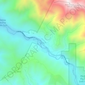
Name: Topografische Karte Big Sur, Höhe, Relief.
Ort: Big Sur, Monterey County, California, United States (36.25024 -121.82745 36.29024 -121.78745)
Durchschnittliche Höhe: 313 m
Minimale Höhe: 20 m
Maximale Höhe: 1.026 m
Andere topografische Karten
Klicken Sie auf eine Karte, um ihre Topografie, ihre Höhe und ihr Relief anzuzeigen.
Pebble Beach
United States > California > Monterey County > Del Monte Forest
Pebble Beach, Del Monte Forest, Monterey County, California, 93953, United States
Durchschnittliche Höhe: 53 m
Bradley
United States > California > Monterey County
Bradley, Monterey County, California, United States
Durchschnittliche Höhe: 190 m
Salinas
United States > California > Monterey County > Salinas
Salinas, Monterey County, California, United States
Durchschnittliche Höhe: 19 m