
Topografische Karte Knoxville
Interaktive Karte
Klicken Sie auf die Karte, um die Höhe anzuzeigen.
Über diese Karte
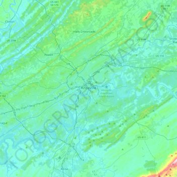
Name: Topografische Karte Knoxville, Höhe, Relief.
Durchschnittliche Höhe: 307 m
Minimale Höhe: 232 m
Maximale Höhe: 881 m
According to the United States Census Bureau, the city has a total area of 104.2 square miles (269.8 km2), of which 98.5 square miles (255.2 km2) is land and 5.6 square miles (14.6 km2), or 5.42%, is water. Elevations range from just over 800 feet (240 m) along the riverfront to just over 1,000 feet (300 m) on various hilltops in West Knoxville, with the downtown area resting at just over 900 feet (270 m). High points include Sharp's Ridge in North Knoxville at 1,391 feet (424 m) and Brown Mountain in South Knoxville at 1,260 feet (380 m). House Mountain, the highest point in Knox County at 2,064 feet (629 m), is located east of the city near Mascot.
Andere topografische Karten
Klicken Sie auf eine Karte, um ihre Topografie, ihre Höhe und ihr Relief anzuzeigen.
Lovell
United States > Tennessee > Knox County
Lovell, Knox County, East Tennessee, Tennessee, 37934, United States
Durchschnittliche Höhe: 291 m