
Topografische Karte Perth County
Klicken Sie auf die Karte, um die Höhe anzuzeigen.
Über diese Karte
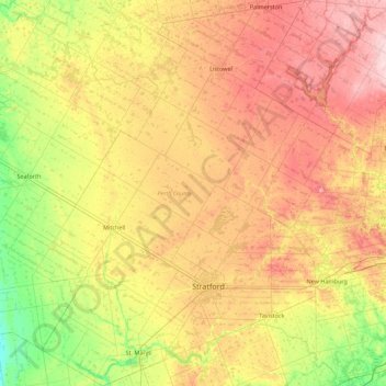
Name: Topografische Karte Perth County, Höhe, Relief.
Ort: Perth County, Southwestern Ontario, Ontario, Canada (43.20333 -81.44310 43.84465 -80.73579)
Durchschnittliche Höhe: 355 m
Minimale Höhe: 266 m
Maximale Höhe: 465 m
Andere topografische Karten
Klicken Sie auf eine Karte, um ihre Topografie, ihre Höhe und ihr Relief anzuzeigen.
Toronto
Malgré la présence de nombreux ravins, Toronto n'est pas une ville spécialement vallonnée. Son altitude est comprise entre 75 mètres au-dessus du niveau de la mer au niveau du lac Ontario et 209 mètres près de l'Université York au nord de la ville, à l'intersection entre la rue Keele et l'avenue Steeles.
Durchschnittliche Höhe: 113 m
Pancake Bay
Canada > Ontario > Algoma District > Unorganized North Algoma
Durchschnittliche Höhe: 180 m
The Swamp - Niagara Escarpment
Canada > Ontario > Grey County > The Blue Mountains
Durchschnittliche Höhe: 454 m
Sainte-Anne-de-Prescott
Canada > Ontario > Comtés unis de Prescott et Russell > East Hawkesbury
Durchschnittliche Höhe: 67 m
Vankleek Hill
Canada > Ontario > Comtés unis de Prescott et Russell > Champlain
Durchschnittliche Höhe: 96 m
Manitouwadge
Canada > Ontario > Thunder Bay District > Manitouwadge Township
Durchschnittliche Höhe: 361 m
Deception Bay
Canada > Ontario > Kenora District > Unorganized Kenora District
Durchschnittliche Höhe: 372 m
Oxford Mills
Canada > Ontario > Leeds and Grenville Counties > North Grenville
Durchschnittliche Höhe: 103 m
Prescott and Russell
Canada > Ontario > Comtés unis de Prescott et Russell
Durchschnittliche Höhe: 166 m
Stormont, Dundas and Glengarry
Canada > Ontario > Stormont, Dundas and Glengarry Counties
Durchschnittliche Höhe: 153 m
St. Isidore
Canada > Ontario > Comtés unis de Prescott et Russell > La Nation
Durchschnittliche Höhe: 63 m
Treadwell
Canada > Ontario > Comtés unis de Prescott et Russell > Alfred and Plantagenet
Durchschnittliche Höhe: 53 m
Dubreuilville
Canada > Ontario > Algoma District > Dubreuilville Township
Durchschnittliche Höhe: 363 m
Saint-Eugène
Canada > Ontario > Comtés unis de Prescott et Russell > East Hawkesbury
Durchschnittliche Höhe: 59 m
Iroquois
Canada > Ontario > Stormont, Dundas and Glengarry Counties > South Dundas
Durchschnittliche Höhe: 80 m
Ellsmere Island
Canada > Ontario > Parry Sound District > The Archipelago Township
Durchschnittliche Höhe: 197 m
L'Orignal
Canada > Ontario > Comtés unis de Prescott et Russell > Champlain
Durchschnittliche Höhe: 49 m
Limoges
Canada > Ontario > Comtés unis de Prescott et Russell > La Nation
Durchschnittliche Höhe: 71 m
Saluit Island
Canada > Ontario > Wellington County > Guelph/Eramosa > Rockwood
Durchschnittliche Höhe: 355 m
Baie Georgienne
Canada > Ontario > Parry Sound District > Carling Township
Durchschnittliche Höhe: 175 m
Rockland
Canada > Ontario > Comtés unis de Prescott et Russell > Rockland
Durchschnittliche Höhe: 59 m
Lac du Rocher Fendu;Rivière des Outaouais
Canada > Ontario > Renfrew County > Whitewater Region
Durchschnittliche Höhe: 94 m
Bowlands Bay
Canada > Ontario > Sudbury District > Greater Sudbury > Skead
Durchschnittliche Höhe: 303 m
Alfred
Canada > Ontario > Comtés unis de Prescott et Russell > Alfred and Plantagenet > Alfred
Durchschnittliche Höhe: 64 m
Cook Island
Canada > Ontario > Algoma District > The North Shore Township
Durchschnittliche Höhe: 177 m
Bourget
Canada > Ontario > Comtés unis de Prescott et Russell > Clarence-Rockland
Durchschnittliche Höhe: 62 m
Chute-à-Blondeau
Canada > Ontario > Comtés unis de Prescott et Russell > East Hawkesbury
Durchschnittliche Höhe: 56 m
Montreal River Harbour
Canada > Ontario > Algoma District > Unorganized North Algoma
Durchschnittliche Höhe: 212 m
Obrey Lake
Canada > Ontario > Kenora District > Unorganized Kenora District
Durchschnittliche Höhe: 382 m