
Spenden
Rüste dich für dein nächstes Abenteuer:
Als Amazon-Partner verdient diese Website an qualifizierten Käufen, ohne zusätzliche Kosten für Sie.
Topografische Karte Walton
Klicken Sie auf die Karte, um die Höhe anzuzeigen.
Spenden
Rüste dich für dein nächstes Abenteuer:
Als Amazon-Partner verdient diese Website an qualifizierten Käufen, ohne zusätzliche Kosten für Sie.
Walton
Walton Hall was built in c.1740–1750 and rebuilt and extended in c.1799 as evidenced by a date stone which is initialled for the contemporary owner Anthony Collett. The building has been known as Walton Hall from c.1813 when the original manorial complex which lay in Walton Village to the east was demolished. The building is set back from the High Street, towards which the front elevation faces
Spenden
Rüste dich für dein nächstes Abenteuer:
Als Amazon-Partner verdient diese Website an qualifizierten Käufen, ohne zusätzliche Kosten für Sie.
Über diese Karte
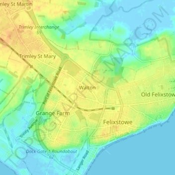
Name: Topografische Karte Walton, Höhe, Relief.
Ort: Walton, Felixstowe, Suffolk, England, IP11 9DT, United Kingdom (51.95180 1.32021 51.99180 1.36021)
Durchschnittliche Höhe: 12 m
Minimale Höhe: -3 m
Maximale Höhe: 27 m
Spenden
Rüste dich für dein nächstes Abenteuer:
Als Amazon-Partner verdient diese Website an qualifizierten Käufen, ohne zusätzliche Kosten für Sie.