Geolokalisieren

Topografische Karte Doons

Interaktive Karte

Klicken Sie auf die Karte, um die Höhe anzuzeigen.

Über diese Karte

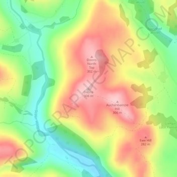
Name: Topografische Karte Doons, Höhe, Relief.

Ort: Doons, Dumfries and Galloway, Scotland, DG3 4NG, United Kingdom (55.25356 -3.86552 55.25366 -3.86542)

Durchschnittliche Höhe: 202 m

Minimale Höhe: 99 m

Maximale Höhe: 308 m

Andere topografische Karten

Klicken Sie auf eine Karte, um ihre Topografie, ihre Höhe und ihr Relief anzuzeigen.

Fingland

United Kingdom > Scotland > Dumfries and Galloway

Fingland, Dumfries and Galloway, Scotland, DG11 2LD, United Kingdom

Durchschnittliche Höhe: 206 m

Durisdeer

United Kingdom > Scotland > Dumfries and Galloway

Durisdeer, Dumfries and Galloway, Scotland, DG3 5BJ, United Kingdom

Durchschnittliche Höhe: 270 m

Eskdalemuir

United Kingdom > Scotland > Dumfries and Galloway

Eskdalemuir, Dumfries and Galloway, Scotland, DG13 0QF, United Kingdom

Durchschnittliche Höhe: 246 m

Moniaive

United Kingdom > Scotland > Dumfries and Galloway

Moniaive, Dumfries and Galloway, Scotland, DG3 4HN, United Kingdom

Durchschnittliche Höhe: 179 m