
Topografische Karte Lebanon
Interaktive Karte
Klicken Sie auf die Karte, um die Höhe anzuzeigen.
Über diese Karte
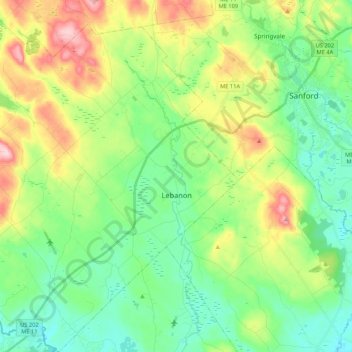
Name: Topografische Karte Lebanon, Höhe, Relief.
Ort: Lebanon, York County, Maine, 04027, United States (43.32569 -70.98843 43.48059 -70.81347)
Durchschnittliche Höhe: 121 m
Minimale Höhe: 51 m
Maximale Höhe: 267 m
According to the United States Census Bureau, the town has a total area of 55.83 square miles (144.60 km2), of which, 55.00 square miles (142.45 km2) of it is land and 0.83 square miles (2.15 km2) is water. Lebanon is drained by the Little River and Salmon Falls River. The town's highest point is Prospect Hill, 880 feet (268 m) above sea level. The lowest elevation borders the Salmon Falls River, on the town's southernmost boundary, which is approximately 170 feet (52 m) above sea level.