
Topografische Karte Ladismith
Interaktive Karte
Klicken Sie auf die Karte, um die Höhe anzuzeigen.
Über diese Karte
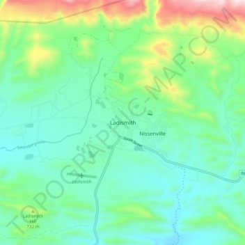
Name: Topografische Karte Ladismith, Höhe, Relief.
Durchschnittliche Höhe: 605 m
Minimale Höhe: 426 m
Maximale Höhe: 1.132 m
It is situated adjacent to a series of fertile, irrigated valleys, at an elevation of 550 m above sea level, at the southern base of the Swartberg. It is currently included in the southern Kannaland Local Municipality. The nearest towns are Calitzdorp to the east, Vanwyksdorp and Riversdale to the south and Laingsburg to the north.
Andere topografische Karten
Klicken Sie auf eine Karte, um ihre Topografie, ihre Höhe und ihr Relief anzuzeigen.
Van Wyksdorp
South Africa > Western Cape > Garden Route District Municipality > Kannaland Local Municipality
Van Wyksdorp, Kannaland Local Municipality, Garden Route District Municipality, Western Cape, South Africa
Durchschnittliche Höhe: 251 m
Calitzdorp
South Africa > Western Cape > Garden Route District Municipality > Kannaland Local Municipality
Calitzdorp, Kannaland Local Municipality, Garden Route District Municipality, Western Cape, South Africa
Durchschnittliche Höhe: 307 m