
Topografische Karte Canyon Springs
Interaktive Karte
Klicken Sie auf die Karte, um die Höhe anzuzeigen.
Über diese Karte
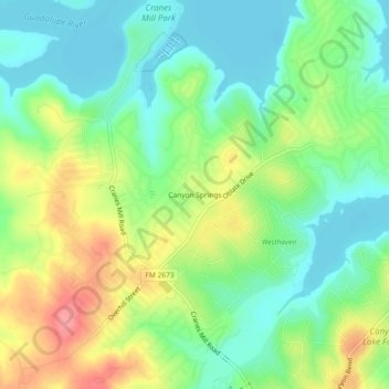
Name: Topografische Karte Canyon Springs, Höhe, Relief.
Ort: Canyon Springs, Comal County, Texas, 79133, United States (29.85272 -98.30751 29.89272 -98.26751)
Durchschnittliche Höhe: 310 m
Minimale Höhe: 274 m
Maximale Höhe: 369 m
Andere topografische Karten
Klicken Sie auf eine Karte, um ihre Topografie, ihre Höhe und ihr Relief anzuzeigen.
Comal River
United States > Texas > Comal County > New Braunfels > Landa Park Estates
Comal River, Landa Park Estates, New Braunfels, Comal County, Texas, 78130, United States
Durchschnittliche Höhe: 206 m
New Braunfels
United States > Texas > Comal County
New Braunfels, Comal County, Texas, United States
Durchschnittliche Höhe: 228 m
Bulverde
United States > Texas > Comal County
Bulverde, Comal County, Texas, United States
Durchschnittliche Höhe: 364 m
Spring Branch
United States > Texas > Comal County
Spring Branch, Comal County, Texas, United States
Durchschnittliche Höhe: 347 m
Canyon Lake
United States > Texas > Comal County
Canyon Lake, Comal County, Texas, 78133, United States
Durchschnittliche Höhe: 296 m