
Topografische Karte Khon Kaen
Interaktive Karte
Klicken Sie auf die Karte, um die Höhe anzuzeigen.
Über diese Karte
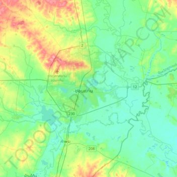
Name: Topografische Karte Khon Kaen, Höhe, Relief.
Ort: Khon Kaen, Mueang Kao, Khon Kaen Province, 40000, Thailand (16.27039 102.67559 16.59039 102.99559)
Durchschnittliche Höhe: 165 m
Minimale Höhe: 144 m
Maximale Höhe: 230 m
Khon Kaen is on the Khorat Plateau, elevation 187 m, and is the center of the mid-northeastern provincial group of Thailand, according to the Thai government. Its coordinates are 16°26′N 102°50′E / 16.433°N 102.833°E / 16.433; 102.833. The city has a population of 114,459.