
Topografische Karte Bison Peak
Interaktive Karte
Klicken Sie auf die Karte, um die Höhe anzuzeigen.
Über diese Karte
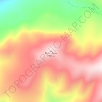
Name: Topografische Karte Bison Peak, Höhe, Relief.
Ort: Bison Peak, Park County, Wyoming, United States of America (44.94239 -110.22691 44.94249 -110.22681)
Durchschnittliche Höhe: 2.447 m
Minimale Höhe: 2.035 m
Maximale Höhe: 2.729 m
Andere topografische Karten
Klicken Sie auf eine Karte, um ihre Topografie, ihre Höhe und ihr Relief anzuzeigen.
Pinedale
United States of America > Wyoming > Pinedale
Pinedale, Sublette County, Wyoming, United States of America
Durchschnittliche Höhe: 2.199 m
Burgess Junction
United States of America > Wyoming > Burgess Junction
Burgess Junction, Sheridan County, Wyoming, United States of America
Durchschnittliche Höhe: 2.459 m
Etna
United States of America > Wyoming
Etna, Lincoln County, Wyoming, United States of America
Durchschnittliche Höhe: 1.765 m
Red Butte
United States of America > Wyoming > Red Butte
Red Butte, Natrona County, Wyoming, 82604, United States of America
Durchschnittliche Höhe: 1.606 m
Wilson
United States of America > Wyoming > Wilson
Wilson, Teton County, Wyoming, United States of America
Durchschnittliche Höhe: 1.953 m
Independence Rock
United States of America > Wyoming
Independence Rock, Natrona County, Wyoming, United States of America
Durchschnittliche Höhe: 1.802 m
Seminoe Dam
United States of America > Wyoming
Seminoe Dam, Carbon County, Wyoming, United States of America
Durchschnittliche Höhe: 2.067 m
Collins Place
United States of America > Wyoming > Collins Place
Collins Place, Fremont County, Wyoming, United States of America
Durchschnittliche Höhe: 2.146 m