
Topografische Karte Province of Yungay
Interaktive Karte
Klicken Sie auf die Karte, um die Höhe anzuzeigen.
Über diese Karte
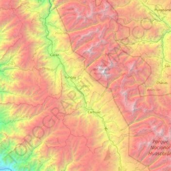
Name: Topografische Karte Province of Yungay, Höhe, Relief.
Ort: Province of Yungay, Ancash, 043, Peru (-9.44661 -78.06229 -8.90044 -77.35751)
Durchschnittliche Höhe: 3.808 m
Minimale Höhe: 800 m
Maximale Höhe: 6.725 m
Andere topografische Karten
Klicken Sie auf eine Karte, um ihre Topografie, ihre Höhe und ihr Relief anzuzeigen.
Laguna Palococha
Laguna Palococha, AN-110, Ticapampa, Province of Recuay, Ancash, Peru
Durchschnittliche Höhe: 3.750 m
Laguna Palococha
Laguna Palococha, AN-110, Ticapampa, Province of Recuay, Ancash, Peru
Durchschnittliche Höhe: 3.765 m
Province of Huaylas
Peru > Ancash > Santa Cruz
Province of Huaylas, Santa Cruz, Huaylas, Ancash, Peru
Durchschnittliche Höhe: 2.353 m
San Cristobal
San Cristobal, Uco, Huari, Ancash, Peru
Durchschnittliche Höhe: 3.607 m
Province of Recuay
Province of Recuay, Cátac, Recuay, Ancash, Peru
Durchschnittliche Höhe: 4.232 m
Laguna Palococha
Laguna Palococha, AN-110, Ticapampa, Recuay, Ancash, Peru
Durchschnittliche Höhe: 3.765 m