
Topografische Karte Richmond County
Interaktive Karte
Klicken Sie auf die Karte, um die Höhe anzuzeigen.
Über diese Karte
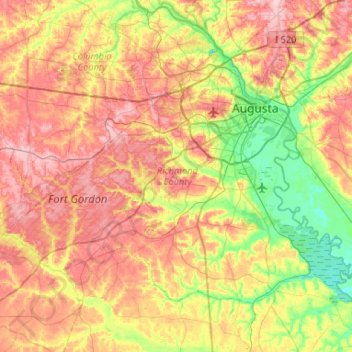
Name: Topografische Karte Richmond County, Höhe, Relief.
Ort: Richmond County, Georgia, United States (33.22717 -82.35387 33.54502 -81.82812)
Durchschnittliche Höhe: 96 m
Minimale Höhe: 22 m
Maximale Höhe: 177 m
Andere topografische Karten
Klicken Sie auf eine Karte, um ihre Topografie, ihre Höhe und ihr Relief anzuzeigen.
Bonair
United States > Georgia > Richmond County > Augusta
Bonair, Augusta, Richmond County, Georgia, 30990, United States
Durchschnittliche Höhe: 84 m
Augusta
United States > Georgia > Richmond County
Augusta, Richmond County, Georgia, United States
Durchschnittliche Höhe: 89 m