
Topografische Karte Trinidad
Interaktive Karte
Klicken Sie auf die Karte, um die Höhe anzuzeigen.
Über diese Karte
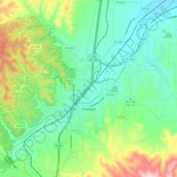
Name: Topografische Karte Trinidad, Höhe, Relief.
Durchschnittliche Höhe: 1.907 m
Minimale Höhe: 1.775 m
Maximale Höhe: 2.219 m
Trinidad is situated in the Purgatoire River valley in far southern Colorado at an elevation of 6,025 ft (1,836 m). The city lies 13 mi north of the New Mexico border. On the northern end of the town is Simpson's Rest, a prominent bluff named for early resident George Simpson, who is buried atop it. North Avenue leads to a rut-prone county road to the top of Simpson's Rest for overviews of the city. The vista from Simpson's Rest includes Fishers Peak, a prominent mountain of 9,600 ft (2,900 m) in elevation, southeast of the city. To the northwest are the prominent Spanish Peaks.
Andere topografische Karten
Klicken Sie auf eine Karte, um ihre Topografie, ihre Höhe und ihr Relief anzuzeigen.
Branson
United States > Colorado > Las Animas County > Branson
Branson, Las Animas County, Colorado, United States
Durchschnittliche Höhe: 1.929 m
Ludlow
United States > Colorado > Las Animas County
Ludlow, Las Animas County, Colorado, United States
Durchschnittliche Höhe: 1.929 m
Starkville
United States > Colorado > Las Animas County > Starkville
Starkville, Las Animas County, Colorado, United States
Durchschnittliche Höhe: 1.988 m