
Topografische Karte Île des gouverneurs
Interaktive Karte
Klicken Sie auf die Karte, um die Höhe anzuzeigen.
Über diese Karte
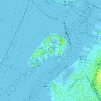
Name: Topografische Karte Île des gouverneurs, Höhe, Relief.
Durchschnittliche Höhe: 1 m
Minimale Höhe: -3 m
Maximale Höhe: 16 m
Andere topografische Karten
Klicken Sie auf eine Karte, um ihre Topografie, ihre Höhe und ihr Relief anzuzeigen.
Brooklyn
États-Unis d'Amérique > New York > New York
Brooklyn, Kings County, New York, États-Unis d'Amérique
Durchschnittliche Höhe: 10 m
New York County
États-Unis d'Amérique > New York > New York
New York County, New York, États-Unis d'Amérique
Durchschnittliche Höhe: 16 m
Queens
États-Unis d'Amérique > New York > New York
Queens, Queens County, New York, États-Unis d'Amérique
Durchschnittliche Höhe: 12 m
Kings County
États-Unis d'Amérique > New York > New York
Kings County, New York, États-Unis d'Amérique
Durchschnittliche Höhe: 9 m
Meatpacking District
États-Unis d'Amérique > New York > New York
Meatpacking District, Manhattan, Manhattan Community Board 2, New York County, New York, 100014, États-Unis d'Amérique
Durchschnittliche Höhe: 9 m
Harlem
États-Unis d'Amérique > New York > New York
Harlem, Manhattan, Manhattan Community Board 10, New York County, New York, États-Unis d'Amérique
Durchschnittliche Höhe: 16 m