
Spenden
Rüste dich für dein nächstes Abenteuer:
Als Amazon-Partner verdient diese Website an qualifizierten Käufen, ohne zusätzliche Kosten für Sie.
Topografische Karte North West Delhi
Klicken Sie auf die Karte, um die Höhe anzuzeigen.
Spenden
Rüste dich für dein nächstes Abenteuer:
Als Amazon-Partner verdient diese Website an qualifizierten Käufen, ohne zusätzliche Kosten für Sie.
Über diese Karte
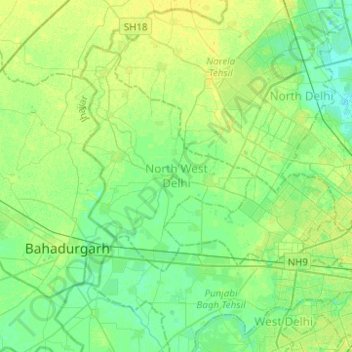
Name: Topografische Karte North West Delhi, Höhe, Relief.
Ort: North West Delhi, India (28.65752 76.94224 28.81825 77.18966)
Durchschnittliche Höhe: 216 m
Minimale Höhe: 209 m
Maximale Höhe: 224 m
Spenden
Rüste dich für dein nächstes Abenteuer:
Als Amazon-Partner verdient diese Website an qualifizierten Käufen, ohne zusätzliche Kosten für Sie.
Andere topografische Karten
Klicken Sie auf eine Karte, um ihre Topografie, ihre Höhe und ihr Relief anzuzeigen.
Maharashtra
Maharashtra is the third largest state by area in India. The Western Ghats better known as Sahyadri, are a hilly range running parallel to the coast, at an average elevation of 1,200 metres (4,000 ft). Kalsubai, a peak in the Sahyadris, near Nashik city is the highest elevated point in Maharashtra. To the west…
Durchschnittliche Höhe: 478 m
Spenden
Rüste dich für dein nächstes Abenteuer:
Als Amazon-Partner verdient diese Website an qualifizierten Käufen, ohne zusätzliche Kosten für Sie.
Guntur
India > Andhra Pradesh > Guntur
Guntur is located at 16°17′N 80°26′E / 16.29°N 80.43°E / 16.29; 80.43. It has an average elevation of 33 m (108 ft) and is situated on the plains. There are few hills in the surrounding suburban areas and Perecherla Reserve Forest on the north west. The city is around 64 km (40 mi) to the west…
Durchschnittliche Höhe: 29 m
Visakhapatnam
India > Andhra Pradesh > Visakhapatnam (Urban)
The city is situated between the Eastern Ghats and the Bay of Bengal. The city coordinates lies between 17.7041 N and 83.2977 E. The city's area is 682 km2. The average elevation is 45 metres. Visakhpatnam is situated in Coastal Andhra Region.
Durchschnittliche Höhe: 35 m
Guwahati
Professor Abani Kumar Bhagawati of Gauhati University stated that since before there were sufficient wetlands to absorb rainwater and channels to carry excess water to the Brahmaputra, the city did not experience floods. However, human interference has disrupted the natural topography, leading to the current…
Durchschnittliche Höhe: 113 m
Chennai
Chennai is located on the south–eastern coast of India in the north–eastern part of Tamil Nadu on a flat coastal plain known as the Eastern Coastal Plains. Its average elevation is around 6.7 metres (22 ft), and its highest point is 60 m (200 ft). Chennai is 2,184 kilometres (1,357 mi) south of Delhi,…
Durchschnittliche Höhe: 7 m
Spenden
Rüste dich für dein nächstes Abenteuer:
Als Amazon-Partner verdient diese Website an qualifizierten Käufen, ohne zusätzliche Kosten für Sie.
Ludhiana
India > Punjab > Ludhiana (West) Tahsil
Ludhiana is located at 30°54′N 75°51′E / 30.9°N 75.85°E / 30.9; 75.85. It has an average elevation of 244 metres (801 ft). Ludhiana City, to its residents, consists of the Old City and the New City. The new city primarily consists of the Civil Lines area which was historically known as the…
Durchschnittliche Höhe: 247 m
Lucknow
India > Uttar Pradesh > Lucknow
Lucknow stands at an elevation of approximately 123 metres (404 ft) above sea level. The city had an area of 402 km2 (155 square miles) until December 2019, when 88 villages were added to the municipal limits and the area increased to 631 km2 (244 square miles). Bounded on the east by Barabanki, on the west by…
Durchschnittliche Höhe: 120 m
Spenden
Rüste dich für dein nächstes Abenteuer:
Als Amazon-Partner verdient diese Website an qualifizierten Käufen, ohne zusätzliche Kosten für Sie.
Udhagamandalam
India > Tamil Nadu > Udhagamandalam
Ooty is situated in the Nilgiri Biosphere Reserve. Many of the forested areas and water bodies are off-limits to most visitors in order to protect this fragile ecosystem. Some areas of the Biosphere Reserve have been earmarked for tourism development, and steps are being undertaken to open these areas to…
Durchschnittliche Höhe: 2.234 m
Spenden
Rüste dich für dein nächstes Abenteuer:
Als Amazon-Partner verdient diese Website an qualifizierten Käufen, ohne zusätzliche Kosten für Sie.
Kalaburagi
India > Karnataka > Kalaburagi taluku
The entire district is on the Deccan Plateau, and the elevation ranges from 300 to 750 m above MSL. Two main rivers, the Krishna and Bhima, flow through the district. The predominant soil type is black soil. The district has many tanks, which irrigate the land along with the river. The Upper Krishna Project is…
Durchschnittliche Höhe: 465 m
Navi Mumbai
India > Maharashtra > Thane > Navi Mumbai
Navi Mumbai (Marathi pronunciation: , also known by its former name New Bombay), is a planned city off the west coast of the Indian state of Maharashtra in Konkan division. The city is divided into two parts, North Navi Mumbai and South Navi Mumbai, for the individual development of Panvel Mega City, which…
Durchschnittliche Höhe: 30 m
Spenden
Rüste dich für dein nächstes Abenteuer:
Als Amazon-Partner verdient diese Website an qualifizierten Käufen, ohne zusätzliche Kosten für Sie.
Mettupalayam
India > Tamil Nadu > Mettupalayam
Mettupalayam is located at 11°18′00″N 76°57′00″E / 11.3000°N 76.9500°E / 11.3000; 76.9500. It has an average elevation of 314 metres (1033 feet). Mettupalayam is situated on the bank of Bhavani River at the foot of the Nilgiri mountains.
Durchschnittliche Höhe: 321 m
Spenden
Rüste dich für dein nächstes Abenteuer:
Als Amazon-Partner verdient diese Website an qualifizierten Käufen, ohne zusätzliche Kosten für Sie.
Mysuru
India > Karnataka > Mysuru taluk
Mysore (/maɪˈsɔːr/ (listen)), officially Mysuru ([ˈmaɪˈsuːɾu] (listen)), is a city in the southern part of the state of Karnataka, India. Mysore city is geographically located between 12° 18′ 26″ north latitude and 76° 38′ 59″ east longitude. It is located at an altitude of 770 m (2,530 ft)…
Durchschnittliche Höhe: 727 m
Spenden
Rüste dich für dein nächstes Abenteuer:
Als Amazon-Partner verdient diese Website an qualifizierten Käufen, ohne zusätzliche Kosten für Sie.
Delhi
India > Delhi > Kotwali Tehsil
The topography of the medieval fort Purana Qila on the banks of the river Yamuna matches the literary description of the citadel Indraprastha in the Sanskrit epic Mahabharata; however, excavations in the area have revealed no signs of an ancient built environment. From the early 13th century until the mid-19th…
Durchschnittliche Höhe: 216 m
Spenden
Rüste dich für dein nächstes Abenteuer:
Als Amazon-Partner verdient diese Website an qualifizierten Käufen, ohne zusätzliche Kosten für Sie.
Mumbai
Mumbai lies at the mouth of the Ulhas River on the western coast of India, in the coastal region known as the Konkan. It sits on Salsette Island (Sashti Island), which it partially shares with the Thane district. Mumbai is bounded by the Arabian Sea to the west. Many parts of the city lie just above sea level,…
Durchschnittliche Höhe: 13 m
Spenden
Rüste dich für dein nächstes Abenteuer:
Als Amazon-Partner verdient diese Website an qualifizierten Käufen, ohne zusätzliche Kosten für Sie.
Spenden
Rüste dich für dein nächstes Abenteuer:
Als Amazon-Partner verdient diese Website an qualifizierten Käufen, ohne zusätzliche Kosten für Sie.
Lansdowne
India > Uttarakhand > Lansdowne
Lansdowne is a quaint hill station in the Pauri Garhwal district of Uttarakhand, India. Lodged in the picturesque surroundings of the Himalayan ranges, it lies at an elevation of approximately 1,700 meters (5,577 feet) above sea level. The town is about 45 kilometers (28 miles) from the district headquarters,…
Durchschnittliche Höhe: 1.140 m
Spenden
Rüste dich für dein nächstes Abenteuer:
Als Amazon-Partner verdient diese Website an qualifizierten Käufen, ohne zusätzliche Kosten für Sie.
Spenden
Rüste dich für dein nächstes Abenteuer:
Als Amazon-Partner verdient diese Website an qualifizierten Käufen, ohne zusätzliche Kosten für Sie.
Spenden
Rüste dich für dein nächstes Abenteuer:
Als Amazon-Partner verdient diese Website an qualifizierten Käufen, ohne zusätzliche Kosten für Sie.
Western Ghats
The range starts near south of the Tapti river and runs approximately 1,600 km (990 mi) through the states of Gujarat, Maharashtra, Karnataka, Goa, Kerala and Tamil Nadu ending at Marunthuvazh Malai, Swamithope near the southern tip of India. These hills cover 160,000 km2 (62,000 sq mi) and form the catchment…
Durchschnittliche Höhe: 2.225 m
Thiruvananthapuram
India > Kerala > Thiruvananthapuram
Thiruvananthapuram is built on seven hills by the seashore and is at 8°30′N 76°54′E / 8.5°N 76.9°E / 8.5; 76.9 on the west coast, near the southern tip of mainland India. The city is on the west coast of India and is bounded by the Laccadive Sea to its west and the Western Ghats to its east.…
Durchschnittliche Höhe: 33 m
Spenden
Rüste dich für dein nächstes Abenteuer:
Als Amazon-Partner verdient diese Website an qualifizierten Käufen, ohne zusätzliche Kosten für Sie.
Spenden
Rüste dich für dein nächstes Abenteuer:
Als Amazon-Partner verdient diese Website an qualifizierten Käufen, ohne zusätzliche Kosten für Sie.
Daulat Beg Oldi
Daulat Beg Oldi (DBO) lies at the northeastern corner of the Karakoram Range, at the northern edge of Depsang Plains at an elevation of 5,100 metres (16,700 ft). The international border with China is 8 km to the north and the Line of Actual Control with Chinese-controlled Aksai Chin is 9 km to the east. Other…
Durchschnittliche Höhe: 5.085 m
Spenden
Rüste dich für dein nächstes Abenteuer:
Als Amazon-Partner verdient diese Website an qualifizierten Käufen, ohne zusätzliche Kosten für Sie.
Gokak
India > Karnataka > Gokak taluku
Gokak is second biggest city after Belgaum city in Belgaum district and is surrounded by the Western Ghats. The Ghataprabha River, which has water almost throughout the year, is the chief source of agricultural and drinking water for local people living in the surrounding villages. It has an average elevation…
Durchschnittliche Höhe: 593 m
Spenden
Rüste dich für dein nächstes Abenteuer:
Als Amazon-Partner verdient diese Website an qualifizierten Käufen, ohne zusätzliche Kosten für Sie.
Paonta Sahib
India > Himachal Pradesh > Paonta Sahib
Paonta Sahib is located at 30°26′17″N 77°37′26″E / 30.438°N 77.624°E / 30.438; 77.624. It has an average elevation of 389 metres (1,276 feet). It is on the bank of the river Yamuna, the river being the boundary between the states of Himachal Pradesh and Uttarakhand. It is situated near the…
Durchschnittliche Höhe: 443 m
Spenden
Rüste dich für dein nächstes Abenteuer:
Als Amazon-Partner verdient diese Website an qualifizierten Käufen, ohne zusätzliche Kosten für Sie.
Spenden
Rüste dich für dein nächstes Abenteuer:
Als Amazon-Partner verdient diese Website an qualifizierten Käufen, ohne zusätzliche Kosten für Sie.
Spenden
Rüste dich für dein nächstes Abenteuer:
Als Amazon-Partner verdient diese Website an qualifizierten Käufen, ohne zusätzliche Kosten für Sie.
Bokaro
Bokaro district consists of undulating uplands on the Chota Nagpur Plateau with the Damodar River cutting a valley right across. It has an average elevation of 200 to 540 metres (660 to 1,770 ft) above mean sea level. The highest hill, Lugu Pahar, rises to a height of 1,070 metres (3,510 ft). The East Bokaro…
Durchschnittliche Höhe: 232 m
Panaji
Panaji was annexed by India with the rest of Goa and the former Portuguese territories after the Indian annexation of Portuguese India in 1961. It became a state-capital on Goa's elevation to statehood in 1987. Between 1961 and 1987, it was the capital of the Union Territory of Goa, Daman and Diu. A new…
Durchschnittliche Höhe: 19 m
Spenden
Rüste dich für dein nächstes Abenteuer:
Als Amazon-Partner verdient diese Website an qualifizierten Käufen, ohne zusätzliche Kosten für Sie.
Leh
Leh (/ˈlɛ/) (Ladakhi: གླེ) is the joint capital and largest city of Ladakh, a union territory of India. Leh, located in the Leh district, was also the historical capital of the Kingdom of Ladakh, the seat of which was in the Leh Palace, the former residence of the royal family of Ladakh, built in the…
Durchschnittliche Höhe: 4.294 m
Mussoorie
India > Uttarakhand > Dehradun
Mussoorie is at an average altitude of 2,005 metres (6,578 ft). To the northeast are the Himalayan snow ranges, and to the south, the Doon Valley and Shiwalik ranges. The second highest point is the original Lal Tibba in Landour, with a height of over 2,275 m (7,464 ft). Mussoorie is popularly known as The…
Durchschnittliche Höhe: 1.594 m
Spenden
Rüste dich für dein nächstes Abenteuer:
Als Amazon-Partner verdient diese Website an qualifizierten Käufen, ohne zusätzliche Kosten für Sie.
Lucknow
India > Uttar Pradesh > Lucknow
The city stands at an elevation of approximately 123 metres (404 ft) above sea level. Lucknow city had an area of 402 km2 (155 square miles) till December 2019, when 88 villages were added to the municipal limits and the area increased to 631 km2 (244 square miles). Bounded on the east by Barabanki, on the…
Durchschnittliche Höhe: 120 m
Shimla
Shimla is on the south-western ranges of the Himalayas at 31°37′N 77°06′E / 31.61°N 77.10°E / 31.61; 77.10. It has an average altitude of 2,206 metres (7,238 ft) above mean sea level and extends along a ridge with seven spurs. The city stretches nearly 9.2 kilometres (5.7 mi) from east to west.
Durchschnittliche Höhe: 1.557 m
Sivakasi
India > Tamil Nadu > Sivakasi
Sivakasi is located at 9°27′00″N 77°49′00″E / 9.45°N 77.8167°E / 9.45; 77.8167 and has an average elevation of 101 metres (331 feet). The city is located in Virudhunagar district of the South Indian state, Tamil Nadu, at a distance of 74 km (46 mi) from Madurai. Sivakasi is located to the…
Durchschnittliche Höhe: 104 m
Kanchipuram
Kanchipuram is located at 12°50′19″N 79°42′06″E / 12.8387°N 79.7016°E / 12.8387; 79.7016, 72 km (45 mi) south-west of Chennai on the banks of the Vegavathi River, a tributary of the Palar River. The city covers an area of 11.6 km2 (4.5 sq mi) and has an elevation of 83.2 m (273 ft) above…
Durchschnittliche Höhe: 82 m
Spenden
Rüste dich für dein nächstes Abenteuer:
Als Amazon-Partner verdient diese Website an qualifizierten Käufen, ohne zusätzliche Kosten für Sie.
Dehradun
India > Uttarakhand > Dehradun
The city of Dehradun mainly lies in Doon Valley and is at a varying height from 410 m (1,350 ft) in Clement Town to above 700 m (2,300 ft) at Malsi which is 15 km (9.3 mi) from the city. However, the average elevation is 450 m (1,480 ft) above sea level. Malsi is the starting point of Lesser Himalayan Range…
Durchschnittliche Höhe: 904 m
Spenden
Rüste dich für dein nächstes Abenteuer:
Als Amazon-Partner verdient diese Website an qualifizierten Käufen, ohne zusätzliche Kosten für Sie.
Chandannagar
India > West Bengal > Singur
Chandannagar is located at 22°52′N 88°23′E / 22.87°N 88.38°E / 22.87; 88.38. It has an average elevation of 10 metres (33 ft).
Durchschnittliche Höhe: 8 m
Spenden
Rüste dich für dein nächstes Abenteuer:
Als Amazon-Partner verdient diese Website an qualifizierten Käufen, ohne zusätzliche Kosten für Sie.