
Topografische Karte Raven Lake
Interaktive Karte
Klicken Sie auf die Karte, um die Höhe anzuzeigen.
Über diese Karte
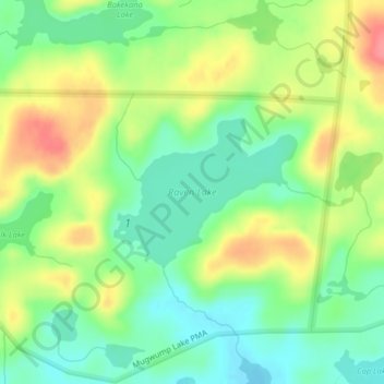
Name: Topografische Karte Raven Lake, Höhe, Relief.
Ort: Raven Lake, Lake County, Minnesota, United States (48.03179 -91.15192 48.04225 -91.13255)
Durchschnittliche Höhe: 507 m
Minimale Höhe: 476 m
Maximale Höhe: 551 m
Andere topografische Karten
Klicken Sie auf eine Karte, um ihre Topografie, ihre Höhe und ihr Relief anzuzeigen.
Coffee Creek
United States > Minnesota > Lake County
Coffee Creek, Lake No. 1, Lake County, Minnesota, United States
Durchschnittliche Höhe: 521 m
Alice Lake
United States > Minnesota > Lake County
Alice Lake, Fall Lake Township, Lake County, Minnesota, United States
Durchschnittliche Höhe: 474 m
Link Lake
United States > Minnesota > Lake County
Link Lake, Lake County, Minnesota, United States
Durchschnittliche Höhe: 452 m
North Shore Mining/Lake Superior Overlook
United States > Minnesota > Lake County > Silver Bay
North Shore Mining/Lake Superior Overlook, City Shop Road, Silver Bay, Lake County, Minnesota, 55614, United States
Durchschnittliche Höhe: 252 m
Fulton Creek
United States > Minnesota > Lake County
Fulton Creek, Lake County, Minnesota, United States
Durchschnittliche Höhe: 560 m
Quartz Lake
United States > Minnesota > Lake County
Quartz Lake, Lake County, Minnesota, United States
Durchschnittliche Höhe: 471 m
Jackfish Lake
United States > Minnesota > Lake County
Jackfish Lake, Lake County, Minnesota, United States
Durchschnittliche Höhe: 411 m
Cook Lake
United States > Minnesota > Lake County
Cook Lake, Lake County, Minnesota, United States
Durchschnittliche Höhe: 534 m
Bonnie Lake
United States > Minnesota > Lake County
Bonnie Lake, Lake County, Minnesota, United States
Durchschnittliche Höhe: 437 m
Makwa Lake
United States > Minnesota > Lake County
Makwa Lake, Lake County, Minnesota, United States
Durchschnittliche Höhe: 509 m
Bright Lake
United States > Minnesota > Lake County
Bright Lake, Lake County, Minnesota, United States
Durchschnittliche Höhe: 431 m
Isabella
United States > Minnesota > Lake County > Isabella
Isabella, Lake County, Minnesota, United States
Durchschnittliche Höhe: 594 m
Jack Lake
United States > Minnesota > Lake County
Jack Lake, Lake County, Minnesota, United States
Durchschnittliche Höhe: 509 m
Pickerel Lake
United States > Minnesota > Lake County
Pickerel Lake, Lake County, Minnesota, United States
Durchschnittliche Höhe: 435 m