
Topografische Karte Thamari
Interaktive Karte
Klicken Sie auf die Karte, um die Höhe anzuzeigen.
Über diese Karte
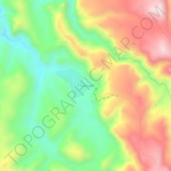
Name: Topografische Karte Thamari, Höhe, Relief.
Ort: Thamari, Potosí, Provincia Tomás Frías, Potosí, Bolivia (-19.36882 -65.76083 -19.32882 -65.72083)
Durchschnittliche Höhe: 3.532 m
Minimale Höhe: 3.280 m
Maximale Höhe: 3.836 m
Andere topografische Karten
Klicken Sie auf eine Karte, um ihre Topografie, ihre Höhe und ihr Relief anzuzeigen.
Huari Huari
Bolivia > Potosí > Provincia Tomás Frías > Potosí
Huari Huari, Potosí, Provincia Tomás Frías, Potosí, Bolivia
Durchschnittliche Höhe: 3.951 m
Manquiri
Bolivia > Potosí > Provincia Tomás Frías > Potosí
Manquiri, Potosí, Provincia Tomás Frías, Potosí, Bolivia
Durchschnittliche Höhe: 3.592 m