
Spenden
Rüste dich für dein nächstes Abenteuer:
Als Amazon-Partner verdient diese Website an qualifizierten Käufen, ohne zusätzliche Kosten für Sie.
Topografische Karte Capitola
Klicken Sie auf die Karte, um die Höhe anzuzeigen.
Spenden
Rüste dich für dein nächstes Abenteuer:
Als Amazon-Partner verdient diese Website an qualifizierten Käufen, ohne zusätzliche Kosten für Sie.
Über diese Karte
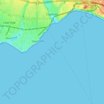
Name: Topografische Karte Capitola, Höhe, Relief.
Durchschnittliche Höhe: 6 m
Minimale Höhe: 0 m
Maximale Höhe: 56 m
Spenden
Rüste dich für dein nächstes Abenteuer:
Als Amazon-Partner verdient diese Website an qualifizierten Käufen, ohne zusätzliche Kosten für Sie.
Andere topografische Karten
Klicken Sie auf eine Karte, um ihre Topografie, ihre Höhe und ihr Relief anzuzeigen.
Live Oak
United States > California > Santa Cruz County > Live Oak
Live Oak is a census-designated place (CDP) in Santa Cruz County, California between the cities of Santa Cruz and Capitola and north of the former Union Pacific railroad. Live Oak sits at an elevation of 102 feet (31 m). The population was 17,038 at the 2020 census. The population of the greater Live Oak area,…
Durchschnittliche Höhe: 47 m
Spenden
Rüste dich für dein nächstes Abenteuer:
Als Amazon-Partner verdient diese Website an qualifizierten Käufen, ohne zusätzliche Kosten für Sie.
Shangri La Estates
United States > California > Santa Cruz County > Pleasure Point
Durchschnittliche Höhe: 12 m
Spenden
Rüste dich für dein nächstes Abenteuer:
Als Amazon-Partner verdient diese Website an qualifizierten Käufen, ohne zusätzliche Kosten für Sie.
Spenden
Rüste dich für dein nächstes Abenteuer:
Als Amazon-Partner verdient diese Website an qualifizierten Käufen, ohne zusätzliche Kosten für Sie.
Spenden
Rüste dich für dein nächstes Abenteuer:
Als Amazon-Partner verdient diese Website an qualifizierten Käufen, ohne zusätzliche Kosten für Sie.
Spenden
Rüste dich für dein nächstes Abenteuer:
Als Amazon-Partner verdient diese Website an qualifizierten Käufen, ohne zusätzliche Kosten für Sie.
Yacht Harbor Manor
United States > California > Santa Cruz County > Live Oak
Durchschnittliche Höhe: 19 m
Australian Garden
United States > California > Santa Cruz County > Santa Cruz
Durchschnittliche Höhe: 131 m
Spenden
Rüste dich für dein nächstes Abenteuer:
Als Amazon-Partner verdient diese Website an qualifizierten Käufen, ohne zusätzliche Kosten für Sie.
Huckleberry Woods
United States > California > Santa Cruz County > Boulder Creek
Durchschnittliche Höhe: 263 m
Spenden
Rüste dich für dein nächstes Abenteuer:
Als Amazon-Partner verdient diese Website an qualifizierten Käufen, ohne zusätzliche Kosten für Sie.
Lomond Terrace
United States > California > Santa Cruz County > Ben Lomond
Durchschnittliche Höhe: 231 m
Spenden
Rüste dich für dein nächstes Abenteuer:
Als Amazon-Partner verdient diese Website an qualifizierten Käufen, ohne zusätzliche Kosten für Sie.