
Topografische Karte Buntzen Lake
Interaktive Karte
Klicken Sie auf die Karte, um die Höhe anzuzeigen.
Über diese Karte
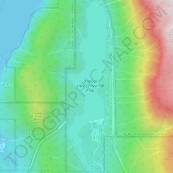
Name: Topografische Karte Buntzen Lake, Höhe, Relief.
Durchschnittliche Höhe: 348 m
Minimale Höhe: 0 m
Maximale Höhe: 1.158 m
Hiking time: 6–8 hours return. Distance: 15 km (9 mi). Elevation gain: 1,020 m (3,350 ft). This is the most popular of the three Halvor Lunden trails. It passes thought ancient mountain forests and has a number of viewpoints from which overlook Vancouver. The trailhead is on Powerhouse Road, near the southeast corner of the South Beach parking area, and takes you up a steep climb of over 700m, passing the Polytrichum Lookout before reaching the "Lake district" which includes several small lakes and the larger Lindsay Lake.
Andere topografische Karten
Klicken Sie auf eine Karte, um ihre Topografie, ihre Höhe und ihr Relief anzuzeigen.
Burrard Inlet
Canada > British Columbia > Metro Vancouver Regional District > Anmore
Burrard Inlet, Anmore, District of North Vancouver, Metro Vancouver Regional District, British Columbia, Canada
Durchschnittliche Höhe: 478 m