
Vielen Dank für die Unterstützung dieser Website ❤️
Spenden
Spenden
Rüste dich für dein nächstes Abenteuer:
Als Amazon-Partner verdient diese Website an qualifizierten Käufen, ohne zusätzliche Kosten für Sie.
Topografische Karte Algoz e Tunes
Klicken Sie auf die Karte, um die Höhe anzuzeigen.
Vielen Dank für die Unterstützung dieser Website ❤️
Spenden
Spenden
Rüste dich für dein nächstes Abenteuer:
Als Amazon-Partner verdient diese Website an qualifizierten Käufen, ohne zusätzliche Kosten für Sie.
Über diese Karte
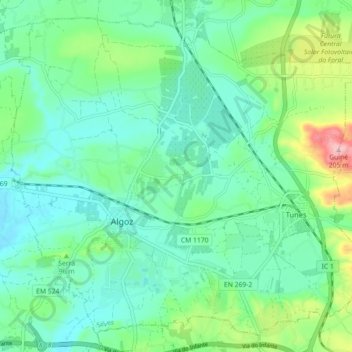
Name: Topografische Karte Algoz e Tunes, Höhe, Relief.
Ort: Algoz e Tunes, Silves, Faro, Algarve, Portugal (37.14096 -8.33048 37.20532 -8.24107)
Durchschnittliche Höhe: 66 m
Minimale Höhe: 21 m
Maximale Höhe: 205 m
Vielen Dank für die Unterstützung dieser Website ❤️
Spenden
Spenden
Rüste dich für dein nächstes Abenteuer:
Als Amazon-Partner verdient diese Website an qualifizierten Käufen, ohne zusätzliche Kosten für Sie.