
Topografische Karte Blue Hill
Interaktive Karte
Klicken Sie auf die Karte, um die Höhe anzuzeigen.
Über diese Karte
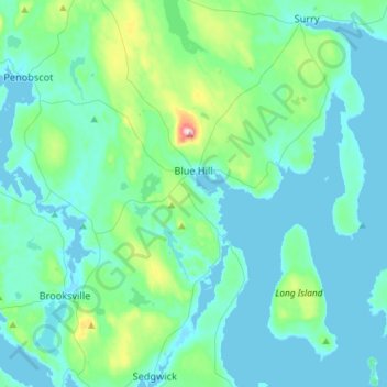
Name: Topografische Karte Blue Hill, Höhe, Relief.
Ort: Blue Hill, Hancock County, Maine, United States (44.29745 -68.69667 44.50539 -68.46241)
Durchschnittliche Höhe: 38 m
Minimale Höhe: -1 m
Maximale Höhe: 279 m
According to the United States Census Bureau, the town has a total area of 86.57 square miles (224.22 km2), of which 62.48 square miles (161.82 km2) is land and 24.09 square miles (62.39 km2) is water. Located on Blue Hill Bay, the town is drained by Mill Brook. Blue Hill, elevation 940 feet (287 meters), is the town's highest point. Long Island, situated in Blue Hill Bay, is part of the town.
Andere topografische Karten
Klicken Sie auf eine Karte, um ihre Topografie, ihre Höhe und ihr Relief anzuzeigen.
Gouldsboro
United States > Maine > Hancock County
Gouldsboro, Hancock County, Maine, United States
Durchschnittliche Höhe: 16 m
Johns Island
United States > Maine > Hancock County > Swan's Island
Johns Island, Swan's Island, Hancock County, Maine, United States
Durchschnittliche Höhe: 0 m
Sister Islands
United States > Maine > Hancock County > Swan's Island
Sister Islands, Swan's Island, Hancock County, Maine, 04635, United States
Durchschnittliche Höhe: 9 m
Trenton
United States > Maine > Hancock County
Trenton, Hancock County, Maine, 04705, United States
Durchschnittliche Höhe: 19 m
Turtle Island
United States > Maine > Hancock County > Winter Harbor
Turtle Island, Winter Harbor, Hancock County, Maine, United States
Durchschnittliche Höhe: 1 m
Frenchboro
United States > Maine > Hancock County
Frenchboro, Hancock County, Maine, 04635, United States
Durchschnittliche Höhe: 2 m
Stonington
United States > Maine > Hancock County
Stonington, Hancock County, Maine, 04681, United States
Durchschnittliche Höhe: 4 m
Southwest Harbor
United States > Maine > Hancock County
Southwest Harbor, Hancock County, Maine, 04679, United States
Durchschnittliche Höhe: 21 m
Franklin
United States > Maine > Hancock County
Franklin, Hancock County, Maine, 04634, United States
Durchschnittliche Höhe: 52 m
Otter Cliffs
United States > Maine > Hancock County > Bar Harbor
Otter Cliffs, Bar Harbor, Hancock County, Maine, United States
Durchschnittliche Höhe: 13 m
Acadia National Park
United States > Maine > Hancock County > Bar Harbor
Acadia National Park, Bar Harbor, Hancock County, Maine, 04609, United States
Durchschnittliche Höhe: 9 m
Aurora
United States > Maine > Hancock County
Aurora, Hancock County, Maine, 04408, United States
Durchschnittliche Höhe: 114 m
Ellsworth
United States > Maine > Hancock County > Ellsworth
Ellsworth, Hancock County, Maine, United States
Durchschnittliche Höhe: 52 m
Carney Island
United States > Maine > Hancock County > Deer Isle
Carney Island, Deer Isle, Hancock County, Maine, United States
Durchschnittliche Höhe: 7 m
Orland
United States > Maine > Hancock County > Orland
Orland, Hancock County, Maine, United States
Durchschnittliche Höhe: 61 m
Bar Harbor
United States > Maine > Hancock County
Bar Harbor, Hancock County, Maine, 04609, United States
Durchschnittliche Höhe: 33 m
Bucksport (CDP)
United States > Maine > Hancock County > Bucksport
Bucksport (CDP), Bucksport, Hancock County, Maine, 04416, United States
Durchschnittliche Höhe: 46 m
Deer Isle
United States > Maine > Hancock County
Deer Isle, Hancock County, Maine, United States
Durchschnittliche Höhe: 10 m
Mount Desert
United States > Maine > Hancock County
Mount Desert, Hancock County, Maine, United States
Durchschnittliche Höhe: 31 m
Saint Helena Island
United States > Maine > Hancock County > Stonington
Saint Helena Island, Stonington, Hancock County, Maine, 04682, United States
Durchschnittliche Höhe: 12 m