
Topografische Karte Welch Island
Interaktive Karte
Klicken Sie auf die Karte, um die Höhe anzuzeigen.
Über diese Karte
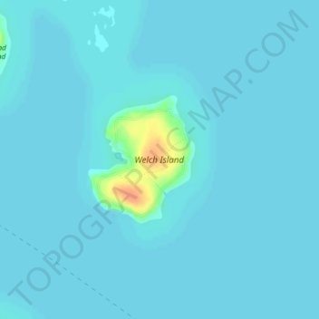
Name: Topografische Karte Welch Island, Höhe, Relief.
Durchschnittliche Höhe: 153 m
Minimale Höhe: 150 m
Maximale Höhe: 187 m
Andere topografische Karten
Klicken Sie auf eine Karte, um ihre Topografie, ihre Höhe und ihr Relief anzuzeigen.
Glendale
United States > New Hampshire > Belknap County > Gilford
Glendale, Gilford, Belknap County, New Hampshire, 03249, United States
Durchschnittliche Höhe: 181 m
Gunstock Mountain
United States > New Hampshire > Belknap County > Gilford
Gunstock Mountain, Gilford, Belknap County, New Hampshire, 03249, United States
Durchschnittliche Höhe: 456 m
Yale Estates
United States > New Hampshire > Belknap County > Gilford > Yale Estates
Yale Estates, Gilford, Belknap County, New Hampshire, United States
Durchschnittliche Höhe: 390 m
Belknap Mountain
United States > New Hampshire > Belknap County > Gilford
Belknap Mountain, Gilford, Belknap County, New Hampshire, 03249, United States
Durchschnittliche Höhe: 498 m