
Topografische Karte Soto la Marina
Interaktive Karte
Klicken Sie auf die Karte, um die Höhe anzuzeigen.
Über diese Karte
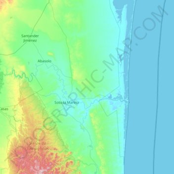
Name: Topografische Karte Soto la Marina, Höhe, Relief.
Ort: Soto la Marina, Tamaulipas, 87678, Mexico (23.27235 -98.51311 24.47880 -97.68071)
Durchschnittliche Höhe: 131 m
Minimale Höhe: -2 m
Maximale Höhe: 1.293 m
Andere topografische Karten
Klicken Sie auf eine Karte, um ihre Topografie, ihre Höhe und ihr Relief anzuzeigen.
Ciudad Mante
Mexico > Tamaulipas > El Mante
El Cielo (The Heaven) a protected cloud forest covers a land mass of 144,530 hectares (~357,129 acres) and is a paradise for the great quantity of species that inhabit it. There are 175 distinct species of migratory birds and 225 local fowl, various amphibious and mammals, as well as white tail deer, jaguar…
Durchschnittliche Höhe: 105 m
Ciudad Victoria
Mexico > Tamaulipas > Victoria
Ciudad Victoria has a climate on the border of humid subtropical (Köppen Cfa/Cwa) and hot semi-arid (BSh). Its weather is characterised by short warm winters and long hot to sweltering summers. Temperatures rarely drop below 0 °C (32 °F) — the lowest recorded temperature was −6 °C (21.2 °F) and the…
Durchschnittliche Höhe: 518 m