
Topografische Karte Georgetown
Interaktive Karte
Klicken Sie auf die Karte, um die Höhe anzuzeigen.
Über diese Karte
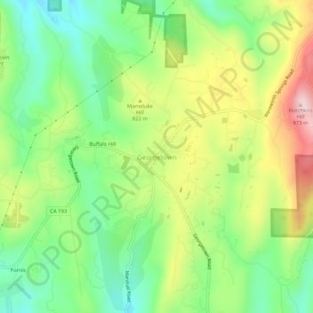
Name: Topografische Karte Georgetown, Höhe, Relief.
Ort: Georgetown, El Dorado County, California, United States (38.88684 -120.85855 38.92684 -120.81855)
Durchschnittliche Höhe: 787 m
Minimale Höhe: 659 m
Maximale Höhe: 978 m
Andere topografische Karten
Klicken Sie auf eine Karte, um ihre Topografie, ihre Höhe und ihr Relief anzuzeigen.
Somerset
United States > California > El Dorado County
Somerset, El Dorado County, California, 95684, United States
Durchschnittliche Höhe: 642 m
Shingle Springs
United States > California > El Dorado County
Shingle Springs, El Dorado County, California, 95682, United States
Durchschnittliche Höhe: 433 m
Placerville
United States > California > El Dorado County
Placerville, El Dorado County, California, 95667, United States
Durchschnittliche Höhe: 586 m
Horseshoe Canyon
United States > California > El Dorado County
Horseshoe Canyon, El Dorado County, California, 95614, United States
Durchschnittliche Höhe: 358 m
South Lake Tahoe
United States > California > El Dorado County
South Lake Tahoe, El Dorado County, California, United States
Durchschnittliche Höhe: 1.979 m
Pitt Lake
United States > California > El Dorado County
Pitt Lake, El Dorado County, California, United States
Durchschnittliche Höhe: 2.414 m