
Topografische Karte Homer
Interaktive Karte
Klicken Sie auf die Karte, um die Höhe anzuzeigen.
Über diese Karte
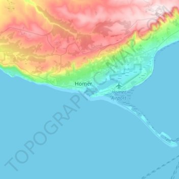
Name: Topografische Karte Homer, Höhe, Relief.
Ort: Homer, Kenai Peninsula, Alaska, United States (59.59827 -151.65504 59.68130 -151.40400)
Durchschnittliche Höhe: 103 m
Minimale Höhe: 0 m
Maximale Höhe: 449 m
Some birds seen during the spring migration and the festival include horned puffins, sandhill cranes, and arctic terns. Arctic Terns are famous for flying the longest distance of any migrating bird. Many of the birds seen during the festival can be identified with the help of published guides that categorize distinguishable features such as, topography, silhouette, size, and color. The festival also includes the Shorebirds Sing: Bird Call Contest, where contestants compete to mimic the calls of various bird species.
Andere topografische Karten
Klicken Sie auf eine Karte, um ihre Topografie, ihre Höhe und ihr Relief anzuzeigen.
Chum Lake
United States > Alaska > Kenai Peninsula
Chum Lake, Kenai Peninsula, Alaska, United States
Durchschnittliche Höhe: 86 m
Big Mink Lake
United States > Alaska > Kenai Peninsula
Big Mink Lake, Kenai Peninsula, Alaska, United States
Durchschnittliche Höhe: 68 m
Mount Douglas
United States > Alaska > Kenai Peninsula
Mount Douglas, Kenai Peninsula, Alaska, United States
Durchschnittliche Höhe: 1.695 m
Kenai
United States > Alaska > Kenai Peninsula
Kenai, Kenai Peninsula, Alaska, United States
Durchschnittliche Höhe: 16 m
Exit Glacier
United States > Alaska > Kenai Peninsula
Exit Glacier, Kenai Peninsula, Alaska, United States
Durchschnittliche Höhe: 1.095 m